Sea Area Forecast
Forecast valid from: 06:00, Tuesday 16 April 2024 until 06:00, Wednesday 17 April 2024
Small Craft Warning
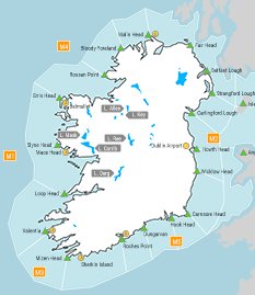
1. Northwesterly winds will reach force 6 or higher this morning (Tuesday) on all Irish coasts. 2. Northwesterly winds will reach force 6 from this afternoon onwards on Irish coasts from Rossan Point to Belfast Lough to Wicklow Head.
Gale Warning
Nil
Atlantic Swell
Nil.
Meteorological Situation at 03:00 UTC
Ireland lies in a strong and unstable northwesterly airflow, with a depression of 993 hPa centred near Denmark. Showery troughs are embedded in the flow.
Small Craft Warning: In effect
Heavy Swell (>4m) : yes
Forecast for all Irish coastal waters and the Irish Sea
Wind: Northwesterly force 5 to 7 and gusty. Imminently decreasing force 4 to 6.
Weather: Fair to cloudy with scattered showers, becoming isolated later.
Visibility: Mostly good, decreasing moderate or poor in any showers.
Outlook for a further 24 hours until 06:00, Thursday 18 April 2024
Moderate to strong northwesterly winds. Becoming light to fresh during Wednesday and light to moderate anticyclonic variable on Wednesday night. Cloudy to fair with isolated showers. Becoming mainly cloudy with outbreaks of rain or drizzle during Wednesday.
Forecast issued at: 06:00, Tuesday 16 April 2024
All times are local unless specified