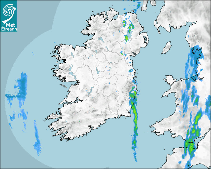

Latest Rainfall Radar showing live precipitation and the last 90 minutes precipitation over Ireland, updated every 5 minutes. Precipitation can be rain, hail or snow. Accumulations can refer to rainfall only.
Lightning strikes, when they occur, are displayed as a cross. Initially, they are red but change to orange and then yellow after a period, then disappear © Met Office ATDNet.
Ground Clutter may appear (South Co. Dublin), bright bands and spokes may also be present in images. They are artefacts (false echoes) of rainfall radar systems and should be ignored. Further information on Radar here
Met Éireann forecasters manually produce the weather icons for midday and midnight to reflect the predicted major weather type for these times.
The rainfall forecast is direct model output from Numerical Weather Prediction models but is a guideline only. Rain refers to precipitation, which can be rain, sleet or snow. It forecasts how much rain will fall (in mm) hourly during the previous hour (accumulations), then in 3 hourly and finally 6 hourly accumulations up to 7 days. This service is based on data and products of the HARMONIE-AROME and the European Centre for Medium-range Weather Forecasts (ECMWF) models.
The wind is direct model output from Numerical Weather Prediction models but is a guideline only. It forecasts the strength of the wind (in knots and km/h) at 10m for the top of each hour, in hourly, then 3 hourly and finally 6 hourly intervals up to 7 days. The wind arrow tip points in the direction the wind is blowing and the tail length indicates wind strength. However, in the text forecast below, it is described as where it is blowing from. This service is based on data and products of the HARMONIE-AROME and the European Centre for Medium-range Weather Forecasts (ECMWF) models.
The temperature is direct model output from Numerical Weather Prediction models but is a guideline only. It forecasts air temperature on land and over sea in °C for the top of each hour, 3 hourly and finally 6 hourly intervals up to 7 days. Minus zero (-0) indicates values between 0 to -0.5°C. This service is based on data and products of the HARMONIE-AROME and the European Centre for Medium-range Weather Forecasts (ECMWF) models.
The Mean Sea Level Pressure (MSLP) is direct model output from Numerical Weather Prediction models but is a guideline only. It forecasts the MSLP in hecto Pascals (hPa) for the top of that hour initially in 3 hourly intervals, then 6 hourly. This service is based on data and products of the HARMONIE-AROME and the European Centre for Medium-range Weather Forecasts (ECMWF) models.
National Forecast
18 January 2026 04:49
Today
Areas of mist and fog to start, gradually clearing from most places through the morning. Dry for many for daylight hours with bright or sunny spells and just occasional showers, mainly in the east. Later this afternoon and evening, outbreaks of rain will develop in the west and southwest. Highest temperatures of 5 to 9 degrees with light to moderate southerly winds freshening in the west during the evening.
Tonight
Cloudy tonight with outbreaks of rain in the west gradually extending eastwards across the country. Lowest temperatures of 1 to 5 degrees, coldest in the east early on, with moderate, occasionally fresh, south to southeast or cyclonic variable winds.
Tomorrow
A cloudy and wet start for most tomorrow, with widespread outbreaks of rain and drizzle. The rain will start to clear northwards through the afternoon with drier and brighter conditions extending from the southwest. Highest temperatures of 5 to 9 degrees with moderate cyclonic variable winds, easing mostly light westerly breezes with the clearance of the rain.
Met News

13th January 2026
Met Éireann presents two awards at action-packed Stripe YSTE
Met Éireann was once again delighted to take part... more

06th January 2026
Annual Climate Statement for 2025
Second warmest year on record with above average r... more

05th January 2026
Met Éireann Internship Opportunities
Met Éireann Internship Opportunities Launch your ... more

05th January 2026
Climate Statement for December 2025
Mild and wet first two thirds, cold and dry final ... more