2023 finished narrowly wetter than 2009 and 2015, the two previous wettest years on record for Ireland
Issued Wednesday 10 July 2024
2023 was the warmest year on record for Ireland (records going back to 1900), and now Met Éireann’s analysis of Ireland’s complete set of quality-controlled rainfall measurements confirms that 2023 was also the wettest year on record in Ireland (records going back to 1941).
The provisional analysis carried out at the end of 2023, using mostly near real-time rainfall observations, had indicated that 2023 was in the top three wettest years on record*. As is Met Éireann’s procedure every year, the collection and inclusion of thousands of manually recorded rainfall observations allows for a more complete analysis and ranking of last year’s rainfall totals.
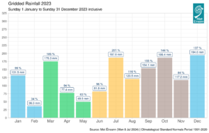
Monthly gridded 2023 rainfall anomalies (% of 1991-2020 long term averages) together with monthly rainfall totals (mm) for Ireland
With all station rainfall observations now included and quality-controlled, 2023 finished narrowly wetter than 2009 and 2015, the two previous wettest years on record.
- 2023 saw the wettest March and wettest July on record (respectively 185% and 201% of their 1991-2020 Long-Term Average (LTA) rainfall).
- Five months saw over 135% of their LTA, mostly during the second half of the year.
- 2023 saw numerous flooding events, particularly in August during storm Betty and in October during storm Babet.
- 2009 now becomes the second wettest year on record with 1506.1 mm gridded average rainfall, versus 1510.9 mm gridded average rainfall in 2023. The driest year on record was in 1971 with 911.8 mm gridded average rainfall.
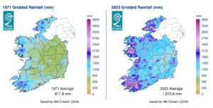
Gridded average Rainfall Totals (mm) for the driest year (1971) and the wettest year (2023) in Ireland
How does the analysis of rainfall observations work?
To provide a timely estimate of how a month or a year ranks in Ireland’s climate record, a ‘provisional’ statement is developed. Largely, observations from Met Éireann’s 25 primary weather stations along with other near real-time weather observations are used in this analysis. It provides a quick look and helps to put our recent weather into a climatological context.
For a more complete analysis, manual rainfall observations from hundreds of Met Éireann manual stations are collected and quality- controlled, a process that takes several months. When this additional data is included in the analysis, it provides a more complete picture of rainfall throughout the year and allows for a more definitive analysis and ranking.
NOTES TO EDITOR:
- Met Éireann would like to acknowledge and thank the hundreds of volunteer weather observers around the county whose dedication, some over a number of decades, is helping to tell Ireland’s climate story.
- For more information on Met Éireann weather stations, please visit: https://www.met.ie/climate/what-we-measure.
- For media enquiries and interview opportunities with a Met Éireann’s spokesperson, please contact media@met.ie. For climate enquiries, please contact Enquiries@met.ie.
* https://www.met.ie/european-state-of-the-climate-2023-climate-of-ireland-2023