Warmest year on record by a large margin, above average rainfall
The first half of January was mild, wet and often windy. The second half was much drier, with high pressure dominating. High pressure continued to dominate through February, which brought very mild and very dry conditions. Storm Otto passed to the north of Ireland on Friday 17th. March was unusually wet and dull (the wettest March on record for Ireland) with low pressure to the southwest dominating. April was mild and changeable. Atlantic low pressure and Scandinavian high pressure brought some dry periods and some wet periods. Storm Noa crossed the country on Wednesday 12th. May was warm, dry and calm as a blocking area of high pressure settled just to the north of Ireland. June was very warm (the warmest June on record in Ireland). High pressure initially brought dry and sunny conditions, before a warm and humid air mass brought periods of intense thunderstorm activity. July was very wet, cool and dull (the wettest July on record in Ireland) as Ireland lay on the cooler northern side of the jet stream and Atlantic low pressure systems dominated. Low pressure continued to dominate through August. Two named storms, storm Antoni on Saturday 5th and storm Betty on Friday 18th were the significant weather events of the month. September brought early heatwaves with record maximum September temperatures in places, followed by numerous heavy rainfall events including storm Agnes on the 27th. October brought further maximum monthly temperature records early, followed by record high October rainfall in the South. Storm Babet brought high rainfall totals between Wednesday 18th and Friday 20th. November was mild overall with a cold finish. It was wet in the Northwest, dry in the Southeast and storm Debi crossed the country on Monday 13th. December started cold but the month was very mild overall with above average rainfall. Storm Elin and storm Fergus crossed the country on Saturday 9th and Sunday 10th. Storm Gerrit and storm Geraldine brought further wet and windy weather towards the end of the year.
Rainfall: Above average at most stations
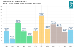
The majority of annual rainfall totals were above their 1981-2010 Long-Term Average (LTA). Percentage of annual rainfall values ranged from 96% (annual rainfall total of 1198.5 mm) at Finner, Co Donegal to 134% (annual rainfall total of 1306.5 mm) at Roche’s Point, Co Cork. Annual rainfall totals ranged from 870.0 mm (115% of its LTA) at Casement Aerodrome, Co Dublin to 1944.6 mm (125% of its LTA) at Valentia Observatory, Co Kerry (its wettest year since 2009). The year’s wettest day was also recorded at Valentia Observatory, Co Kerry with 74.0 mm on Friday 18th August during storm Betty. The number of rain days ranged from 212 days at Phoenix Park, Co Dublin to 283 days at Knock Airport, Co Mayo. The number of wet days* ranged from 142 days at Phoenix Park, Co Dublin to 227 days at Valentia Observatory, Co Kerry. The number of very wet days* ranged from 22 days at Casement Aerodrome, Co Dublin to 69 days at Valentia Observatory, Co Kerry. It was the wettest year on record at Athenry, Co Galway with 1590.2 mm (133% of its LTA) (since it’s station’s records began 12 years ago). It was the wettest year since 2002 at Dublin Airport, Co Dublin with 1001.2 mm (132% of its LTA). It was the wettest year since 2008 at Phoenix Park, Co Dublin with 961.4 mm (124% of its LTA). It was the wettest year since 2009 at Cork Airport, Co Cork with 1527.3 mm (124% of its LTA), Sherkin Island, Co Cork with 1377.7 mm (116% of its LTA), Dunsany, Co Meath with 1048.2 mm (121% of its LTA) and Johnstown Castle, Co Wexford with 1295.3 mm (122% of its LTA). There were 67 separate dry periods (absolute droughts*, partial droughts* and dry spells*) observed in Ireland during 2023, all of which occurred between January and June. Of these 34 were dry spells at 25 stations, 24 were absolute droughts at 24 stations and 9 were partial droughts at seven stations.

Provisional monthly gridded 2023 rainfall anomalies (% of 1981-2010) together with monthly rainfall totals
Temperature: Above average everywhere, warmest year on record by a large margin
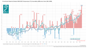
Overall (using the Island of Ireland dataset*), 2023’s average shaded air temperature in Ireland is provisionally 11.20 °C, which is 1.65°C above the 1961-1990 LTA. This makes 2023 the second consecutive warmest year on record, 0.35 °C warmer than 2022 the previous warmest year.
All mean air temperatures across the country were above their annual LTA. Deviations from mean air temperature for the year ranged from 0.7 °C at both Markree, Co Sligo (10.4 °C mean temperature) and Sherkin Island, Co Cork (11.9 °C mean temperature) to 1.5 °C at Phoenix Park, Co Dublin (11.2 °C mean temperature). Mean temperatures for the year ranged from 9.9 °C (1.4 °C above its LTA) at Knock Airport, Co Mayo (its warmest year on record (22 years)) to 11.9 °C at both Valentia Observatory, Co Kerry (1.1 °C above its LTA) (its warmest year on record (83 years)) and Sherkin Island, Co Cork (0.7 °C above its LTA) (its warmest year since 2007). The year’s lowest temperatures were recorded on Tuesday 17th January with the lowest air minimum of -7.0 °C reported at Mount Dillon, Co Roscommon and the lowest grass minimum of -11.7 °C reported at Ballyhaise, Co Cavan. The highest maximum was reported on Tuesday 13th June at Oak Park, Co Carlow with a temperature of 28.8 °C. All stations reported air and ground frost during the year. The number of days with ground frost ranged from 19 days at Sherkin Island, Co Cork to 120 days at Mount Dillon, Co Roscommon. The number of days with air frost ranged from 1 day at both Sherkin Island, Co Cork and Roche’s Point, Co Cork to 47 days at Mount Dillon, Co Roscommon. It was the warmest year on record at 21 stations (record lengths between 10 and 83 years). Eighteen stations had their highest mean maximum temperature on record and twenty-four stations had their highest mean minimum temperature on record. Heatwave* conditions were reported at four stations between Monday 4th and Saturday 9th September lasting between 5 and 6 days.

Island of Ireland annual average temperature anomalies (1961-1990 Long-Term Average) 1900 to 2023: 2023 average shaded air temperature in Ireland is provisionally 11.20°C which is 1.65°C above the 1961-1990 LTA
Sunshine: Sunniest in the East
All available sunshine totals were above their LTA. Percentage of annual sunshine values were 106% at both Shannon Airport, Co Clare (annual sunshine total of 1383.9 hours) and Casement Aerodrome, Co Dublin (annual sunshine total of 1456.4 hours). Annual sunshine totals ranged from 1162.1 hours (No LTA comparison*) at Valentia Observatory, Co Kerry to 1467.6 hours (No LTA comparison*) at Johnstown Castle, Co Wexford. The highest number of daily sunshine hours recorded this year was 16.0 hours at Malin Head, Co Donegal on Tuesday 30th May, Friday 9th Jun and Thursday 15th Jun. The number of dull days* ranged from 75 days at Dublin Airport to 115 days at Valentia Observatory, Co Kerry.
Wind: Eleven named storms directly affected Ireland, storm force winds were reported during storm Noa and storm Fergus
Annual mean wind speeds ranged from 5.8 knots (10.7 km/h) at Ballyhaise, Co Cavan to 14.6 knots (27.0 km/h) at Malin Head, Co Donegal. There were numerous days with gales and strong-gales. Storm force winds were reported on Thursday 12th January at Mace Head, Co Galway, Wednesday 12th April at Sherkin Island, Co Cork (during storm Noa), Wednesday 1st November at Mace Head and Sunday 10th December at Mace Head (during storm Fergus). The number of days with up to strong gales ranged from zero at a few stations to 10 days at Mace Head, Co Galway. The number of days with storm force winds was up to 3 days at Mace Head, Co Galway. The year’s highest gust of 66 knots (122 km/h) was reported at both Mace Head, Co Galway on Thursday 12th January and Sherkin Island, Co Cork on Wednesday 12th April (during storm Noa). The highest 10-minute wind speed was 49 knots (91 km/h) reported at Mace Head, Co Galway on Sunday 10th December (during storm Fergus).
The full report is available here (select ‘Year’ in drop down menu)

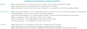
2023 extreme values at synoptic stations
Station records and heatwaves:
Rainfall:
- Four stations had their wettest March on record (record lengths between 12 to 59 years). These were Athenry, Co Galway with 185.9 mm (196% of its LTA), Mace Head, Co Galway with 151.2 mm (142% of its LTA), Mount Dillon, Co Roscommon with 169.8 mm (192% of its LTA) and Casement Aerodrome, Co Dublin with 109.3 mm (215% of its LTA). Dublin Airport with 119.3 mm (226% of its LTA) and Phoenix Park, Co Dublin with 121.3 mm (224% of its LTA) had their wettest March since 1947. Valentia Observatory, Co Kerry with 239.2 mm (193% of its LTA) had its wettest March since 1963.
- Twelve stations had their wettest July on record (record lengths range from 12 to 83 years). These were Dunsany, Co Meath with 184.5 mm (300% of its LTA), Athenry, Co Galway with 224.1 mm (259% of its LTA), Phoenix Park, Co Dublin with 149.1 mm (271% of its LTA), Shannon Airport, Co Clare with 155.0 mm (235% of its LTA), Malin Head, Co Donegal with 192.6 mm (238% of its LTA), Belmullet, Co Mayo with 148.5 mm (187% of its LTA), Moore Park, Co Cork with 150.1 mm (242% of its LTA), Ballyhaise, Co Cavan with 154.7 mm (210% of its LTA), Knock Airport, Co Mayo with 203.7 mm (212% of its LTA), Gurteen, Co Tipperary with 163.3 mm (244% of its LTA), Mount Dillon, Co Roscommon with 206.0 mm (281% of its LTA) and Finner, Co Donegal with 158.1 mm (173% of its LTA). Seventeen stations over 200% of their LTA for July.
- Johnstown Castle, Co Wexford had its wettest September since 1974 with 178.4 mm (203% of its LTA). Both Roches Point, Co Cork with 145.9 mm (172% of its LTA) and Cork Airport with 171.4 mm (181% of its LTA) had their wettest September since 2006. Both Shannon Airport, Co Clare with 113.8 mm (151% of its LTA) and Mullingar, Co Westmeath with 132.9 mm (170% of its LTA) had their wettest September since 2010.
- Three Cork stations had their wettest October on record. These were Cork Airport with 307.2 mm (222% of its LTA)(record length 61 years), Roches Point with 242.1 mm (222% of its LTA)(length 19 years) and Moore Park with 250.8 mm (221% of its LTA)(length 59 years). Johnstown Castle had its wettest October since 2002 with 265.0 mm (217% of its LTA). Both Phoenix Park with 131.4 mm (165% of its LTA) and Casement Aerodrome with 116.0 mm (142% of its LTA) had their wettest October since 2011 and Dublin Airport had its wettest October since 2013 with 126.1 mm (160% of its LTA).
Temperatures:
- Seven stations reported their warmest May on record (record lengths between 13 and 123 years). These were Phoenix Park, Co Dublin with a mean temperature of 12.9 °C (2.1 °C above its LTA)(joint warmest with May 2022), Oak Park, Co Carlow with 13.1 °C (2.1 °C above its LTA), Moore Park, Co Cork with 13.2 °C (2.1 °C above its LTA), Roches Point, Co Cork with 12.9 °C (1.5 °C above its LTA), Dunsany, Co Meath with 12.2 °C (1.7 °C above its LTA, Athenry, Co Galway with 12.6 °C (1.3 °C above its LTA) and Cork Airport, Co Cork with 12.8 °C (2.0 °C above its LTA).
- Twenty-three stations had their warmest June on record (record lengths between 12 to 83 years). The two remaining stations, Dublin Airport and Phoenix Park, Co Dublin had their warmest June since 1976. Nineteen stations had their highest mean minimum for June on record. Athenry, Co Galway and Shannon Airport, Co Clare experienced 27 consecutive days with maximum air temperatures > 20 °C.
- Heatwaves were reported at four stations between Monday 4th and Friday 8th September lasting between 5 and 6 days. Fourteen stations broke their September maximum temperature records (record lengths between 12 and 81 years). These were Oak Park, Co Carlow with 28.5 °C, Dublin Airport with 26.1 °C, Casement Aerodrome, Co Dublin with 27.3 °C, Mullingar, Co Westmeath with 28.0 °C, Dunsany, Co Meath with 28.4 °C, Markree, Co Sligo with 26.9 °C, Ballyhaise, Co Cavan with 26.8 °C, Finner, Co Donegal with 26.8 °C, Mount Dillon, Co Roscommon with 28.1 °C, Athenry, Co Galway with 27.7 °C, Claremorris, Co Mayo with 27.4 °C, Belmullet, Co Mayo with 26.2 °C, Newport, Co Mayo with 27.9 °C and Knock Airport, Co Mayo with 26.2 °C. Ten stations broke their September highest minimum temperature record.
- Nine stations broke their October maximum temperature records (record lengths between 15 and 81 years). These were Phoenix Park with 23.4 °C, Dublin Airport with 23.2 °C, Ballyhaise, Co Cavan with 21.2 °C, Markree, Co Sligo with 21.4 °C, Dunsany with 22.1 °C, Gurteen, Co Tipperary with 22.8 °C, Mount Dillon with 22.5 °C, Casement Aerodrome, Co Dublin with 22.9 °C and Knock Airport with 19.8 °C.
Climate Change Context
Ireland’s warming trend continued in 2023, in line with the global warming trend. One contributing factor to Ireland having such a warm and wet 2023 is the record high sea surface temperatures (SST) across the North Atlantic since April. Along with this came a severe marine heatwave to the west of Ireland during the month of June. This contributed to the increase in both the mean temperatures and moisture content in the atmosphere over Ireland. In 2023 we saw numerous flooding events in Ireland, especially during the second half of the year, with ‘compound events’ involving heavy rainfall and tidal lock on the rise (compound events are combinations of multiple climate impact drivers that occur at the same time, in the same area or both).
Climatologist Paul Moore said: “2023 has turned out to be an extraordinary climatological year with climate change driving a surge in extreme weather events and record high temperatures around the world. In Ireland, we have set the second consecutive warmest year on record with the annual mean temperature for Ireland breaching 11 °C for the first time. We have also seen one of the wettest years on record in Ireland”
The latest Irish climate change projections indicate further warming in the future. This temperature change means the likelihood of extreme weather events occurring has increased. Irish rainfall patterns are expected to change, with an increase in both dry periods and heavy rainfall events. Global sea level continues to rise. As a result, storm surge and coastal flooding risk around Irish coasts is expected to increase along with ‘compound events’ involving heavy rainfall and high tides combined. It is currently unclear how the frequency and intensity of storms impacting Ireland will change with climate change. There is high confidence, however, that maximum rainfall rates associated with these storms will increase with warming. Climate change projections also indicate a trend toward warmer winters, although under the right background conditions cold periods cannot be ruled out in any particular year.
*Issued by Met Éireann on Thursday 4th January 2024. This report is based on available preliminary data from 25 principal weather stations operated by Met Éireann. Synoptic station data is midnight to midnight UTC. Long-Term Averages (LTAs) and “average” refer to the period 1981-2010 unless stated. A wet day is a day with 1.0 mm or more of rainfall. A dull day is a day with less than 0.5 hours of sunshine. A very wet day is a day with 10.0 mm or more of rainfall. Climatological dry periods – An absolute drought is a period of 15 or more consecutive days to none of which is credited 0.2 mm or more of precipitation. A partial drought is a period of at least 29 consecutive days, the mean daily rainfall of which does not exceed 0.2 mm. A dry spell is a period of 15 or more consecutive days to none of which is credited 1.0 mm or more of precipitation (i.e. daily tot < 1.0 mm). A heatwave occurs where there are 5 consecutive days or more with maximum temperature over 25°C (that is, a daily maximum screen air temperature > 25° C). The Island of Ireland dataset is 124 years long and runs between 1900 and 2023. For this dataset the long term averages from the 1961-1990 reference period are used for comparison as is standard for long-term climate change assessments. *Sunshine data is from the Autosol Network. LTAs for these sites are currently not used for comparison purposes. For more information, contact Met Éireann at 01-8064200 or e-mail: enq@met.ie