Mild. Wet first half, dry second half
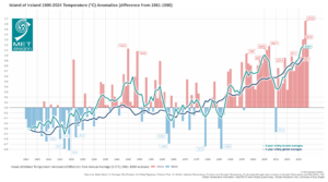
- The average annual air temperature for Ireland in 2024 (using the Island of Ireland dataset*) was 10.72 °C, which is 1.17°C above the 1961-1990 long-term average (LTA) or 0.55°C above the most recent 1991-2020 LTA.
- This makes 2024 the fourth warmest year on record, 0.49 °C cooler than 2023, the warmest year on record.
- The five warmest years on record are 2023, 2022, 2007, 2024 and 1945. Seven of the top ten warmest years have occurred since 2005.
- The coldest year on record was in 1919 with 8.73 °C, of the top ten coldest years – none have occurred since 2000.
- Provisionally, 2024 rainfall was the 41st driest or 44th wettest since 1941.

2024 Climate Statistics
January was cold, dry and sunny overall with high pressure to the north in control for most of the month. Two named storms, Isha named by the Met Office (UK) and Jocelyn named by Met Éireann, directly affected Ireland between Sunday 21st and Wednesday 24th. February was mild and wet with Atlantic low pressure dominating in a mostly west to south-westerly airflow. March and April were mild and wet months dominated by Atlantic low pressure. However, a southerly shifted jet stream directed low pressure systems over or to the south of Ireland, bringing the bulk of the rainfall to the Midlands, South and East. Storm Kathleen, named by Met Éireann, affected Ireland on Saturday 6th April. May was exceptionally mild (the warmest May on record in Ireland), especially at night, but dull overall. Weak steering currents brought a mixture of slow-moving high and low pressure. Rainfall totals were mixed, with a thundery spell between Tuesday 14th and Friday 24th. June and July were relatively cool and dry months overall. The first half of June and first third of July saw cold Arctic airflows from north dominate. The second half of June saw milder Atlantic westerlies take control, while the final two thirds of July were mixed with a warmer finish. August was cool and wet in the North and West with Atlantic low pressure dominating. It was warmer and drier further east where high pressure to the south was more influential. September was cool and dry overall. High pressure to the north kept it drier and sunnier in the West and North, while low pressure to the south brought wetter and duller conditions to the East and South at times. October was mild everywhere and dryer than average for most, apart from the Southwest. High pressure to the north brought dry spells, but Low pressure to the south dominated at times. Storm Ashley, named by Met Éireann, moved close to the northwest coast on Sunday 20th. November was mild and relatively dry overall, but dull. The first half of the month was dominated by anticyclonic gloom, while the second half was cooler, wetter and windier with lying snow in places. Storm Bert, named by Met Éireann, affected Ireland on Saturday 23rd. December was the eight month in 2024 with drier than average conditions. It was mild with high pressure dominating. Storm Darragh, named by the Met Office (UK), brought the strongest winds of the year on Friday 6th.
Rainfall: Below average at most stations, wettest in the South
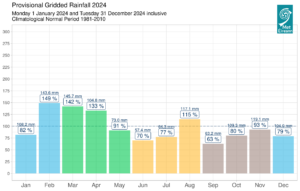
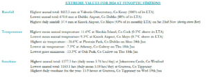
The majority of annual rainfall totals across the country were below their Long-Term Average 1981-2010 (LTA). Percentage of annual rainfall values ranged from 80% (693.3 mm) at Dunsany, Co Meath (its driest year since 2001) to 111% at both Roche’s Point, Co Cork (1084.0 mm) and Johnstown Castle, Co Wexford (1176.1 mm). Annual rainfall totals ranged from 670.0 mm (88% of its LTA) at Dublin Airport, Co Dublin to 1652.3 mm (106% of its LTA) at Valentia Observatory, Co Kerry. The highest daily rainfall total was 57.4 mm at Knock Airport, Co Mayo on Saturday 23rd November (during storm Bert). The number of rain days* ranged from 198 days at Dublin Airport to 279 days at Knock Airport, Co Mayo. The number of wet days* ranged from 129 days at Phoenix Park, Co Dublin to 220 days at Valentia Observatory, Co Kerry. The number of very wet days* ranged from 13 days at Dunsany, Co Meath to 53 days at both Newport, Co Mayo and Valentia Observatory, Co Kerry. It was the driest year on record at Finner, Co Donegal with 1036.9 mm (record length 13 years). It was the driest year since 2010 at Ballyhaise, Co Cavan with 874.6 mm. There were 15 separate dry periods (absolute droughts*, partial droughts* and dry spells*) observed in Ireland during 2024 between Tuesday 2nd January and Friday 15th November. Of these 14 were dry spells at 13 stations, 1 absolute drought at one station (Moore Park, Co Cork in January) and zero partial droughts.

Provisional monthly gridded 2024 rainfall anomalies (% of 1981-2010) together with monthly rainfall totals
Temperature: Above average everywhere
All mean air temperatures across the country were above their annual LTA. Deviations from mean air temperature ranged from 0.1 °C (9.8 °C mean temperature) at Markree, Co Sligo to 1.1 °C (10.7 °C mean temperature) at Phoenix Park, Co Dublin. Mean temperatures for the year ranged from 9.3 °C (0.7 °C above its LTA) at Knock Airport, Co Mayo to 11.6 °C (0.5 °C above its LTA) at Sherkin Island, Co Cork. The lowest temperatures of the year were recorded on Thursday 18th January. The lowest air minimum was reported at Athenry, Co Galway with a temperature of -7.3 °C and the lowest grass minimum reported at Oak Park, Co Carlow with -13.3 °C. The highest maximum of the year was reported on Monday 24th June at Phoenix Park, Co Dublin with a temperature of 26.6 °C. All stations reported air and ground frost during the year. The number of days with ground frost ranged from 23 days at Roche’s Point, Co Cork to 114 days at Mullingar, Co Westmeath. The number of days with air frost ranged from 1 day at Malin Head, Co Donegal to 44 days at Mount Dillon, Co Roscommon.

Island of Ireland annual average temperature anomalies (1961-1990 Long-Term Average) 1900 to 2024: 2024 average shaded air temperature in Ireland is provisionally 10.72°C which is 1.17°C above the 1961-1990 LTA
Sunshine: Dull overall, sunniest in the East
Percentage of LTA sunshine values were variable (where available) across the country. Percentage of annual sunshine values ranged from 89% (annual sunshine total of 1278.4 hours) at Cork Airport, Co Cork to 101% (annual sunshine total of 1318.3 hours) at Shannon Airport, Co Clare. Annual sunshine totals ranged from 1163.1 hours (no LTA comparison*) at Gurteen, Co Tipperary to 1377.5 hours (no LTA comparison*) at Johnstown Castle, Co Wexford. The highest number of daily sunshine hours recorded this year was 15.9 hours at Gurteen, Co Tipperary on Wednesday 19th June. The number of dull days* ranged from 100 days at Casement Aerodrome, Co Dublin to 112 days at Dublin Airport, Co Dublin.
Wind: Seven named storms directly affected Ireland, violent storm force winds were reported during storms Isha and Darragh
Annual mean wind speeds ranged from 5.9 knots (10.9 km/h) at Moore Park, Co Cork, Ballyhaise, Co Cavan to 14.9 knots (27.6 km/h) at Malin Head, Co Donegal. There were numerous days with gales and strong gales. Storm force winds were reported Sunday 21st and Monday 22nd January during storm Isha, Tuesday 23rd January during storm Jocelyn, Sunday 20th October during storm Ashley, Saturday 23rd November during storm Bert, Friday 6th and Saturday 7th December during storm Darragh and Sunday 22nd December. Violent storm force winds were reported Sunday 21st January during storm Isha and Friday 6th December during storm Darragh. The number of days with up to strong gales ranged from zero days at a few stations to 14 days at Malin Head, Co Donegal. The number of days with storm force winds were up to 5 days at both Mace Head, Co Galway and Malin Head, Co Donegal. Both the year’s highest gust and 10-minute mean wind speed was reported at Mace Head, Co Galway on Friday 6th December during storm Darragh. The highest gust was 76 knots (141 km/h) while the year’s highest 10-minute mean wind speed was 60 knots (111 km/h).
The full report is available here (select ‘Year’ in drop down menu)

2024 extreme values at synoptic stations
Station records and monthly extremes in 2024:
Rainfall:
- In January nine stations in the Midlands, South and East had dry spells* lasting between 16 and 17 days and one station, Moore Park, Co Cork, had an absolute drought* lasting 16 days.
- In February nine stations had over 150% of their February LTA rainfall and two stations in the Southwest had over 200% of their February LTA rainfall.
- Dublin Airport and Phoenix Park, Co Dublin had their wettest March day on record on Friday 1st (length 83 years) and Mount Dillon, Co Roscommon had its wettest March day on record on Thursday 14th (length 19 years).
- Valentia Observatory, Co Kerry had its wettest March since 1963.
- Eight stations had their wettest April since 2009 and Johnstown Castle, Co Wexford had its wettest April since 2002.
- May saw 91% (73.0 mm) of its LTA rainfall.
- June was the driest month of 2024 with 70% (57.4mm) of its LTA rainfall.
- July saw 77% (64.3 mm) of its LTA rainfall.
- Two stations, Malin Head, Co Donegal (length 69 years) and Knock Airport, Co Mayo (length 28 years), had their wettest August on record.
- Newport, Co Mayo had its 2nd wettest August on record and wettest since 1985 (length 65 years). Belmullet, Co Mayo had its wettest August since 1992.
- Cork Airport, Co Cork saw its highest daily fall in September since 1965 with 51.3 mm on Sunday 29th.
- Nine stations, mostly in the West and Northwest, had their driest September since 2014.
- It was the driest October in Ireland since 2018.
- Sherkin Island, Co Cork saw its highest daily fall in October on record with 54.2 mm on Saturday 5th (length 52 years).
- Three stations, Knock Airport, Co Mayo, Oak Park, Co Carlow and Finner, Co Donegal had their highest daily fall in November on record on Saturday 23rd (lengths between 13 and 27 years) and in total ten stations had over 40 mm on Saturday 23rd during storm Bert.
- Dunsany, Co Meath had its driest December since 2001. Dublin Airport had its driest December since 2008. Three stations, Mace Head, Co Galway, Mullingar, Co Westmeath and Gurteen, Co Tipperary had their driest December since 2010. Six stations in the South had their driest December since 2014.
Temperatures:
- The January maximum temperature of 15.4 °C, at Belmullet, Co Mayo, was its highest maximum temperature for January on record (length 67 years).
- There were four icing days* reported during January.
- Seven stations had their warmest February on record, including five station in the Southwest (record lengths from 19 to 84 years). Valentia Observatory, Co Kerry with a mean temperature of 9.25 °C had its warmest February on record in its 125-year data series.
- Nine stations had their highest minimum for February on record (record lengths range from 8 to 49 years).
- Five stations, with no air frost during, March had their highest minimum temperature for March on record (record lengths range from 19 to 84 years).
- Two stations, Johnstown Castle, Co Wexford (length 54 years) and Roches Point, Co Cork (length 19 years) had their highest minimum temperature for April on record.
- May 2024 was the warmest May on record in Ireland (length 125 years).
- It was the warmest May on record at thirteen out of 25 stations including Phoenix Park, Co Dublin and Malin Head, Co Donegal which have record lengths of 125 years.
- Three stations had their highest mean maximum temperature for May on record.
- Fourteen stations had their highest mean minimum for May on record.
- Spring 2024 was the 2nd warmest spring on record (record length 125 years).
- Both June and July saw below average temperatures.
- Five stations had their coldest July since 2015 and twelve stations had their lowest mean minimum for July since 2015.
- It was the coldest August since 2018 at eight stations and coldest since 2017 at twelve stations.
- Summer 2024 was the first cooler than average season since spring 2021 (13 seasons previous).
- It was the coldest September since 2018 at seventeen stations and the coldest at two stations since 2015.
- The first frost of autumn was observed Friday 13th September, the earliest first autumn frost for 32 years.
- It was the 23rd warmest October on record (length 125 years).
- It was the 10th warmest November on record (length 125 years).
- Eleven stations reported their highest November maximum temperature on record on Wednesday 6th.
- It was the 9th warmest December on record (length 125 years).
Sunshine:
- Shannon Airport, Co Clare had its sunniest January on record (length 78 years).
- Shannon Airport, Co Clare and Dublin Airport, Co Dublin had their dullest May since 2014.
- August saw the highest overall monthly sunshine total of 188.2 hours (125% of its LTA) at Casement Aerodrome, Co Dublin.
- Malin Head, Co Donegal had its dullest December since 2011.
Wind:
- In January violent storm force winds were reported during storm Isha and storms force winds were reported during storm Jocelyn.
- Storm Kathleen brought strong gales in April.
- Storm Lilian brought gales in August and six stations had their highest mean wind for August on record (record lengths between 13 and 20 years).
- Storm Ashley brought storm force winds in October.
- Storm Bert brought storm force winds in November.
- Storm Darragh brought violent storm force winds and the strongest winds of the year in December.
Climate Change Context
Ireland’s overall warming trend continues in line with the global warming trend. Seven of the top ten warmest years in Ireland have occurred since 2005, with 2024 the fourth warmest year on record. Sea surface temperatures (SST) across the North Atlantic have continued at or near record high levels. This contributes to higher than average mean temperatures and increased moisture content in the atmosphere over Ireland. Although 2024 was overall drier than average, there were many instances of heavy or intense rainfall which led to flooding. Compound events, which involve multiple climate impact drivers occurring at the same time, are on the rise.
Climatologist Paul Moore said: “2024 was Ireland’s fourth warmest year on record, even though it may not have always felt that way, especially during the cooler than average summer months. It was often cloudy during 2024 and this, along with continued high sea surface temperatures across the North Atlantic, led to higher nighttime temperatures being more influential, which drove the overall average temperatures up”.
The latest Irish climate change projections indicate further warming in the future. This temperature change means the likelihood of extreme weather events occurring has increased. Irish rainfall patterns are expected to change, with an increase in both dry periods and heavy rainfall events. Global sea levels continues to rise. As a result, storm surge and coastal flooding risk around Irish coasts is expected to increase along with ‘compound events’ involving a combination of heavy rainfall and high tides. It is currently unclear how the frequency and intensity of storms impacting Ireland will change with climate change. There is high confidence, however, that maximum rainfall rates associated with these storms will increase with warming.
*Issued by Met Éireann on Monday 6th January 2025. This report is based on available preliminary data from 25 principal weather stations operated by Met Éireann. Synoptic station data is midnight to midnight UTC. Long-Term Averages (LTAs) and “average” refer to the period 1981-2010 unless stated. A rain day is a day on which 0.2 mm or more of rainfall is measured. A wet day is a day with 1.0 mm or more of rainfall. A dull day is a day with less than 0.5 hours of sunshine. A very wet day is a day with 10.0 mm or more of rainfall. Climatological dry periods – An absolute drought is a period of 15 or more consecutive days to none of which is credited 0.2 mm or more of precipitation. A partial drought is a period of at least 29 consecutive days, the mean daily rainfall of which does not exceed 0.2 mm. A dry spell is a period of 15 or more consecutive days to none of which is credited 1.0 mm or more of precipitation (i.e. daily tot < 1.0 mm). A heatwave occurs where there are 5 consecutive days or more with maximum temperature over 25°C (that is, a daily maximum screen air temperature > 25° C). An icing day occurs at a station when the daily maximum air temperature falls below 0°C. The ‘Island of Ireland’ dataset is 125 years long and runs between 1900 and 2023. For this dataset the long term averages from the 1961-1990 reference period are used for comparison as is standard for long-term climate change assessments. *Sunshine data is from the Autosol Network. LTAs for these sites are currently not used for comparison purposes. For more information, contact Met Éireann at 01-8064200 or e-mail: enq@met.ie