Issued 16th August 2024
At the end of June, the first major hurricane, Beryl, kicked-started the season in the Atlantic on what promises to be a bumper year for the Atlantic hurricane season. Beryl caused extensive damage in the Caribbean Islands and was followed by Debby in early August which made landfall in Florida on August 5th. Currently Hurricane Ernesto lies in the western Atlantic (See Fig 1) with the National Hurricane Centre predicting Ernesto to bring strong winds and heavy rainfall to Bermuda through the weekend.
Met Éireann will be monitoring the evolution of Ernesto and any potential influence it could have on our weather next week. For more information on this and how Hurricane Debby indirectly influenced our weather last weekend keep reading.
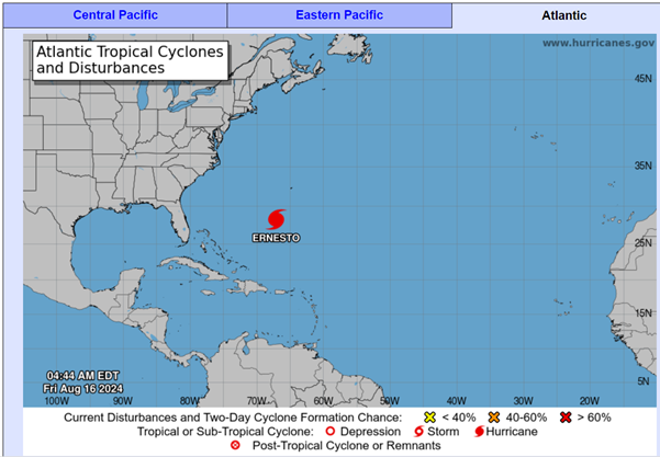
Fig 1: Location of Hurricane Ernesto – valid 1100 UTC 16 Aug 2024. Source: NOAA National Hurricane Centre
All the seasonal hurricane predictions have called for an above average Atlantic hurricane season in 2024 and Beryl was the earliest calendar year category 4 hurricane on record (which stretches back 77 years, with the last 50 years being the most reliable as it’s when satellites became a reliable source of information). The peak of the Atlantic hurricane season usually occurs around September 10th with most hurricanes usually happening between mid-August and mid-October.
Above average season predicted for 2024/2025, but…why?
Sea surface temperatures in the tropical Atlantic are well above average for the time of year and we are heading into a La Niña by late summer which typically favours increased Atlantic hurricane activity due to a decrease in vertical wind shear. Low vertical wind shear helps storms to sustain themselves in the tropics, so they can potentially strengthen more often into hurricanes.
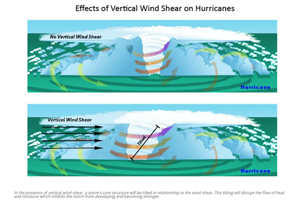
Fig 2: Effects of Vertical Wind Shear on Hurricanes. Source: NOAA National Hurricane Centre
What is the difference between tropical cyclones and hurricanes, or in other words, when do we start talking about a “hurricane”?
Whether it’s a hurricane, tropical cyclone or typhoon really depends on which oceanic basin they form in. They all start out as tropical cyclones but once a tropical cyclone reaches maximum sustained winds of 119km/h (74 mph) or higher, it is then classified as a hurricane, typhoon, or tropical cyclone, depending upon where the storm originates in the world. In the North Atlantic, central North Pacific, and eastern North Pacific, the term hurricane is used.
Do Atlantic hurricanes affect the weather in Ireland?
Hurricanes do influence, mostly indirectly, our weather here in Ireland. Sometimes they push warmer tropical maritime airmasses towards us which can be good news if it’s accompanied by high pressure, but when those tropical airmasses are accompanied by low pressure it can result in unstable warm humid air, causing thunderstorms and potentially severe flooding.
An example of an indirect influence happened just last week with hurricane/tropical storm Debby. Even though Debby did not directly affect Ireland, it did lead to a temporary pattern change towards the end of last week. As Debby moved north through the eastern US and into Canada on Friday 9th August, it caused a buckle in the jet stream, which in turn led to a trough in the mid-Atlantic. This trough caused a ridge of high pressure to build north over Ireland temporarily on Saturday 10th August followed by a surge of very warm air from the south on Sunday 11th. This in turn led to an outbreak of intense thunderstorm activity across the country late on Sunday 11th and into Monday morning as the trough approached from the west pushing up against the very warm airmass in place over Ireland.
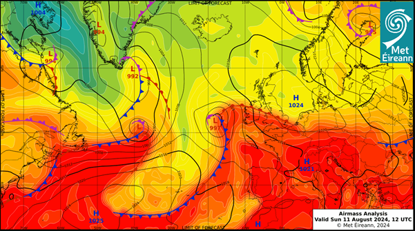
Fig 3: Surface analysis chart valid 1200 UTC 11th August 2024 depicting very warm air mass temperatures over much of Ireland. Source: Met Éireann.
Obviously, hurricanes can influence us directly as well, but by the time they reach Ireland they are usually no longer classified as hurricanes, having transitioned into what is known as “post- or extra-tropical storms.” However, they can still be quite powerful and damaging – Ophelia (2017), Charley (1986) & Debbie (1961).
Numerical Weather Prediction (NWP) models also tend to struggle with accurate prediction of the rapid intensification of hurricanes and this has downstream effects on the reliability of the long-term outlook of model forecasts, increasing uncertainty. This is the perfect example of the “Butterfly Effect”: the notion that the flap of a butterfly’s wing in Brazil can set off a cascade of atmospheric events that, weeks later, spurs the formation of a tornado in Texas.
Will Hurricane Ernesto affect our weather next week?
Hurricane Ernesto is forecast to transition to a mid-latitude storm near northeastern Canada early next week with its remnants then tracking eastwards into the open Atlantic. As is typical with these systems there is a high degree of uncertainty in the forecast, but current indications suggest Ireland may experience some associated wet and windy weather on Wednesday (21st Aug) through to Thursday (22nd of Aug).
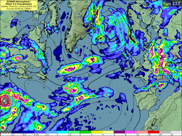
Fig 4: MSLP and 6-hour precipitation forecast chart valid 12 UTC 18th August 2024. Ernesto can be seen coming into the western extend of the forecast domain. Source: ECMWF.
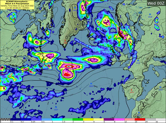
Fig 5: MSLP and 6-hour precipitation forecast chart valid 00 UTC 21st August 2024. The system has weakened and is located mid Atlantic. Source: ECMWF.
Met Éireann will be monitoring its evolution over the coming days so stay in contact with the forecast at www.met.ie or on the Met Éireann app.
Hurricanes and Climate Change – What to expect.
Although climate change is not expected to lead to more tropical storms or hurricanes forming over the Atlantic in the future, the storms that do develop will have the potential to becoming stronger and more intense. Sea surface temperatures (SSTs) of at least 27° Celsius are required to maintain tropical systems. As the world continues to warm, SSTs of 27° Celsius or higher will expand further north in the Atlantic to higher latitudes, enabling storms to maintain tropical status for longer as they travel north.
Want to know more about Hurricanes?
- Listen to our meteorologists speak with John Cangialosi, a senior hurricane specialist from the National Hurricane Centre in Florida, at The Met Éireann Podcast.

References:
- NOAA National Hurricane Centre: https://www.nhc.noaa.gov/
- Hurricane Season 2018