Cold, dry first half, wet second half
The first half of December 2022 saw very cold arctic air masses dominating, with high pressure to the north and the Jetstream displaced well to the south of Ireland, leading to drier than average conditions. The second half of the month was less cold with Atlantic low pressure systems dominating bringing wetter than average conditions. During the first week, high pressure, centred initially to the northeast over Scandinavia, brought a progressively cooler easterly airflow, after a relatively mild start. It was mostly dry apart from some heavy showers in Eastern and Southern coastal counties mid-week. High pressure moved from Scandinavia towards Greenland at the end of the first week, setting up a much colder northerly airflow for the second week. This brought wintry showers, mostly to windward facing coasts of the East and North, with lying snow in places, along with severe frosts and ice days (where the maximum temperature in a day does not rise above 0.0 °C), especially inland. The third week started cold and frosty before a very mild southerly airflow swept across the country on the 18th ending the cold spell. The final two weeks of the month saw Atlantic low pressure systems to the west and north in charge, bringing rain or showers on most days, in a mostly southerly to westerly airflow. The rainfall was especially widespread and heavy between the 23rd and 25th, thundery in places on the 24th, and again between the 28th and 30th with numerous active weather fronts crossing the country.
Rainfall: Below average in most places
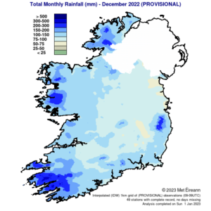
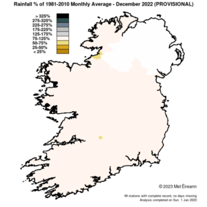
The majority of monthly rainfall totals across the country were below their 1981-2010 Long-Term Average (LTA). Percentage of monthly rainfall values ranged from 71% (monthly rainfall total of 93.0 mm) at Finner, Co Donegal to 136% (the month’s highest monthly rainfall total of 187.1 mm) at Belmullet, Co Mayo. Monthly rainfall totals were lowest at Oak Park, Co Carlow with 68.0 mm (81% of its LTA). The month’s wettest day was also recorded at Belmullet, Co Mayo with 41.3 mm on Christmas Day, Sunday 25th. The number of rain days ranged from 15 days at Oak Park, Co Carlow to 28 days at Malin Head, Co Donegal. The number of wet days ranged from 9 days at Ballyhaise, Co Cavan to 22 days at both Malin Head, Co Donegal and Belmullet, Co Mayo. The number of very wet days ranged from 2 days at a few stations to 8 days at Newport, Co Mayo.

Total Monthly Rainfall (mm) for December 2022 (Provisional)

Rainfall % of 1981 – 2010 Monthly Average for December 2022 (Provisional)
Temperature: Below average everywhere, coldest December since 2010
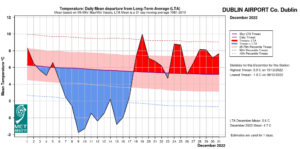
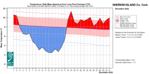
All mean air temperatures across the country were below their LTA for the month. Deviations from mean air temperature ranged from -2.7 °C (3.0 °C mean temperature) at Markree, Co Sligo (its coldest December since 2010) to -0.7 °C (5.7 °C mean temperature) at Malin Head, Co Donegal (its coldest December since 2011). Mean temperatures for the month ranged from 2.8 °C (2.2 °C below its LTA) at Mount Dillon, Co Roscommon (its coldest December since 2010) to 7.0 °C (1.0 °C below its LTA) at Sherkin Island, Co Cork (its coldest December since 2010). The month’s highest temperature was reported at Phoenix Park, Co Dublin on Monday 19th with a temperature of 15.0 °C. The month’s lowest air and grass minimum were recorded at Mount Dillon, Co Roscommon with the lowest air temperature reported on Friday 16th with -8.8 °C (its lowest minimum in December since 2010 and the lowest minimum in Ireland since December 2010), while the lowest grass minimum was -13.0 °C (its lowest grass minimum in December on record (length 18 years)) reported on Wednesday 14th. All stations reported air and ground frost during the month. The number of days with ground frost ranged from 8 days at Sherkin Island, Co Cork to 28 days at Markree, Co Sligo. The number of days with air frost ranged from 2 days at Malin Head, Co Donegal to 14 days at Mount Dillon, Co Roscommon. Eleven stations had an ice day (where the maximum temperature in a day does not rise above 0.0 °C) on Monday 12th, four of those stations had a second consecutive ice day on Tuesday 13th and one station, Ballyhaise, Co Cavan, had a third consecutive ice day on Wednesday 14th. Ballyhaise also had the coldest daily maximum temperature at any synoptic station since December 2010 with a maximum of -3.1 °C on Monday 12th.

Dublin Airport Temperature: Daily mean departure from LTA for December 2022. More graphs here, click ‘Temp Graph’

Sherkin Island, Co Cork Temperature: Daily mean departure from LTA for December 2022. More graphs here, click ‘Temp Graph’
Sunshine: Sunny in most places
All available sunshine totals were above their LTA. Percentage of monthly sunshine values ranged from 143% (monthly sunshine total of 68.3 hours) at Casement Aerodrome, Co Dublin to 152% (monthly sunshine total of 68.6 hours) at Shannon Airport, Co Clare. Monthly sunshine totals ranged from 30.9 hours (No LTA comparison*) at Malin Head, Co Donegal to 78.7 hours (No LTA comparison*) at Cork Airport, Co Cork. The highest number of daily sunshine hours recorded this month was 7.0 hours at Cork Airport, Co Cork on Thursday 15th. The number of dull days ranged from 7 days at Johnstown Castle, Co Wexford to 13 days at Gurteen, Co Tipperary.
Wind: Strong gales reported
Monthly mean wind speeds ranged from 5.1 knots (9.5 km/h) at Mount Dillon, Co Roscommon to 15.6 knots (28.9 km/h) at Malin Head, Co Donegal. Gales were reported on 7 days during the month with up to strong gale winds reported on Wednesday 21st. The number of days with gales ranged from zero days at most stations to 5 days at Mace Head, Co Galway. The number of days with up to strong gales ranged from zero at most stations to 1 day at Mace Head, Co Galway. Both the month’s highest gust and 10-minute mean wind speed was reported on Wednesday 21st. The highest gust was 56 knots (104 km/h) reported at Belmullet, Co Mayo while the month’s highest 10-minute mean wind speed was 41 knots (76 km/h) at Mace Head, Co Galway.
The full report is available here

December 2022 extreme values at synoptic stations
Recent Decembers in Ireland:
- 2016: Nearly all stations reported below Long-Term Average (LTA) for rainfall and all stations reported above LTA mean temperatures.
- 2017: Rainfall was above average at most stations, the majority of mean air temperatures were above average, sunshine totals were below overall and Storm force winds were reported during Storm Dylan.
- 2018: Most stations had above normal rainfall, highest in the South. All mean air temperatures across the country were above while all stations had below-average sunshine totals and Storm Deirdre brought strong gale-force winds.
- 2019: Monthly rainfall totals were variable across the country, mean air temperatures were above everywhere, all stations had above-average sunshine totals and strong gales were reported during Storm Elsa and Storm Atiyah.
- 2020: Rainfall was above average and temperatures were below average in most places, while sunshine totals were above average everywhere and storm-force winds were reported during Storm Bella
- 2021: The majority of monthly rainfall totals were above average, all mean air temperatures were above, sunshine totals were variable, and violent storm force 11 winds were reported during Storm Barra.