Winter 2021/2022 (December, January, February)
Unusually mild Winter (provisional statistics)
- Winter 2022 was the 6th warmest in 123 Winters
- Warmer Winters were: 1943, 1975, 1989, 1998, 2019
- 7th consecutive Winter, at or above normal (1961-1990)
- Winter temperatures in Ireland have increased by 0.65°C since 1900
- In the top 5% of Winter Temperatures, which makes it an unusually mild Winter
Very mild, rainfall just above average overall, windy at times
A strong stratospheric polar vortex helped to keep the North Atlantic Oscillation mostly positive during winter 2021/22, apart from a period during the second half of December when high pressure over Greenland pushed the low-pressure systems in the Atlantic further south. This meant that for most of winter, the North Atlantic Jetstream stayed to the north, with Ireland on the warmer southern side. Consequently, the low-pressure storm tracks also stayed mostly to the north and west of Ireland, with high pressure to the south. December was mild with low-pressure dominating the first and final thirds of the month bringing above average rainfall. The middle third of the month saw below average rainfall with high pressure in control. Storm Barra, named by Met Éireann, brought severe winds on Tuesday 7th and Wednesday 8th. January saw high pressure to the south and east of Ireland dominating, which brought mild and dry conditions. Two storms brought strong winds as they passed by to the north of Ireland towards the end of the month. Storm Malik, named by DMI (Denmark), on Saturday 29th and storm Corrie, named Met Office (UK), on Sunday 30th. February was mild and wet with low-pressure to the north in control. Three storms, all named by the Met Office (UK), brought strong to severe winds during February. Storm Dudley on Wednesday 16th, storm Eunice on Friday 18th and storm Franklin on Sunday 20th and Monday 21st.
Rainfall: Just above average overall, lowest in the Southwest
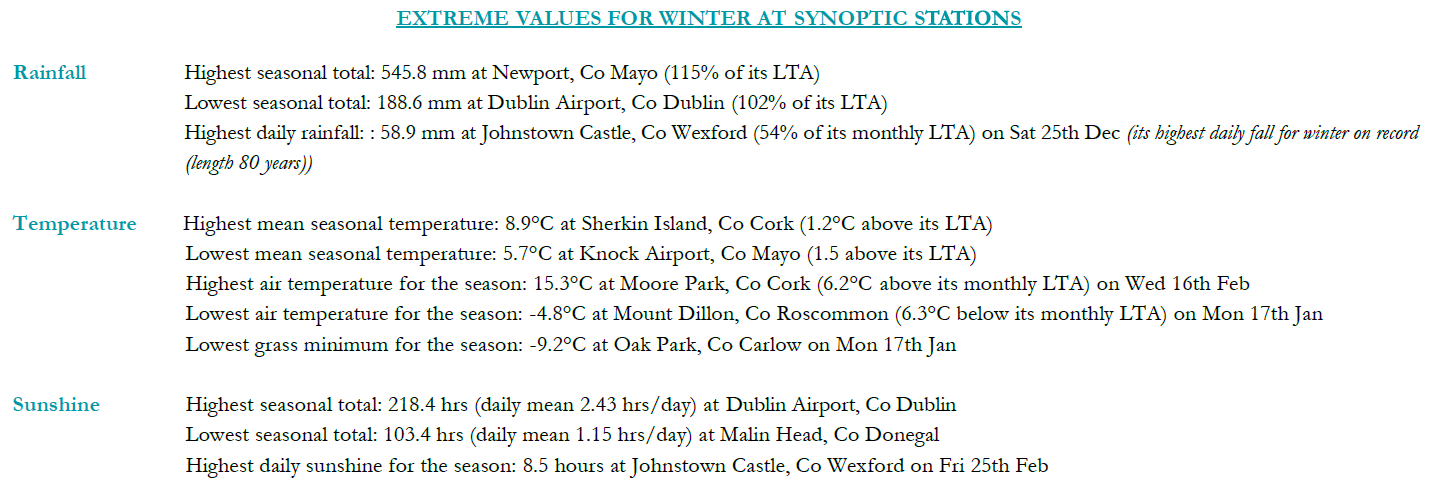
Percentage of Long-Term Average (LTA) rainfall values were variable across the country. Percentage of seasonal rainfall values ranged from 76% (seasonal rainfall total of 276.0 mm) at Sherkin Island, Co Cork to 119% at both Mullingar, Co Westmeath (seasonal rainfall total of 307.4 mm) and Malin Head, Co Donegal (seasonal rainfall total of 385.6 mm). Seasonal rainfall totals for the season ranged from 188.6 mm (102% of its LTA) at Dublin Airport, Co Dublin to 545.8 mm (115% of its LTA) at Newport, Co Mayo. The highest daily rainfall total was 58.9 mm at Johnstown Castle, Co Wexford on Saturday 25th Dec (its highest daily fall for winter on record (length 80 years)). The number of rain days ranged from 51 days at a few stations to 77 days at Belmullet, Co Mayo. The number of wet days1 ranged from 32 days at Dublin Airport, Co Dublin to 62 days at Newport, Co Mayo. The number of very wet days3 ranged from 4 days at Oak Park, Co Carlow to 18 days at Newport, Co Mayo. Nine stations had dry spells6 between Saturday 8th and Sunday 30th January.
Temperature: Above average everywhere, unusually mild
All mean air temperatures across the country were above their Long-Term Average (LTA) for the season. Deviations from mean air temperature ranged from 0.8 °C (6.2 °C mean temperature) at Dublin Airport, Co Dublin to 1.8 °C (7.2 °C mean temperature) at Finner, Co Donegal. Mean temperatures for the season ranged from 5.7 °C (1.5 °C above its LTA) at Knock Airport, Co Mayo to 8.9 °C (1.2 °C above its LTA) at Sherkin Island, Co Cork. The season’s lowest temperatures were recorded on Monday 17th Jan with the lowest air minimum reported at Mount Dillon, Co Roscommon with a temperature of -4.8 °C and the lowest grass minimum reported at Oak Park, Co Carlow with -9.2 °C. The highest maximum was reported on Wednesday 16th Feb at Moore Park, Co Cork with a temperature of 15.3 °C. All stations reported ground frost during the season. The number of days with ground frost ranged from 7 days at Belmullet, Co Mayo to 55 days at Phoenix Park, Co Dublin. More than half of stations reported air frost. The number of days with air frost ranged from zero days at a few stations to 16 days at Mullingar, Co Westmeath.
Sunshine: Dullest in the Northwest, sunniest in the East and Southeast
Percentage of seasonal sunshine values ranged from 112% (seasonal sunshine total of 181.4 hours) at Shannon Airport, Co Clare to 113% (seasonal sunshine total of 195.5 hours) at Casement Aerodrome, Co Dublin. Seasonal sunshine totals ranged from 103.4 hours (No LTA comparison*) at Malin Head, Co Donegal to 218.4 hours (No LTA comparison*) at Dublin Airport, Co Dublin. The highest number of daily sunshine hours recorded this season was 8.5 hours at Johnstown Castle, Co Wexford on Friday 25th Feb. The number of dull days2 ranged from 28 days at Dublin Airport, Co Dublin to 42 days at Belmullet, Co Mayo.
Wind: Gales, strong gales, storm force and violent storm force winds reported and six named storms
Seasonal mean wind speeds ranged from 6.6 knots (12.2 km/h) at Moore Park, Co Cork to 18.4 knots (34.1 km/h) at Malin Head, Co Donegal. There were numerous days with gales and strong gales with up to storm force winds on Tuesday 7th Dec and Wednesday 8th Dec during storm Barra, Saturday 1st Jan, Friday 18th Feb during storm Eunice, Sunday 20th Feb and Monday 21st Feb during storm Franklin. There were violent storm force winds recorded on Tuesday 7th December at Mace Head, Co Galway during Storm Barra and on Friday 18th Feb at Roches Point, Co Cork during storm Eunice. The number of days with up to strong gales ranged from zero days at a few stations to 14 days at Mace Head, Co Galway. The number of days with storm force winds were up to 4 days at Mace Head, Co Galway. The season’s highest gust was reported at Mace Head, Co Galway on Sunday 20th Feb with 75 knots (138 km/h) during storm Franklin. The season’s highest 10-minute mean wind speed was 57 knots (105 km/h) at Roche’s Point, Co Cork on Friday 18th Feb during storm Eunice.
The full report is available here
Recent Februarys in Ireland were unsettled and stormy
- 2017 was mild. Half of the stations reported monthly rainfall totals below their Long-Term Average (LTA) and air temperatures across the country were all above their LTA. Storms Ewan and Doris affected Ireland.
- 2018 was cold, sunny and dry. Nearly all rainfall totals were below their LTA and air temperatures across the country were below their LTA.
- 2019 was very mild and mostly dry. Rainfall totals were below their LTA and air temperatures across the country were above their LTA. Storm Erik affected Ireland.
- 2020 was exceptionally wet and very windy. All rainfall totals were above their LTA and nearly all mean air temperatures were above their LTA. Storms Ciara, Dennis and Jorge affected Ireland.
- 2021 was mild overall and wet, especially in the South. Rainfall totals were above their LTA and nearly all mean air temperatures were above their LTA. Storm Darcy affected Ireland.
February 2022
Mild, wet and windy
February was mild and wet with low-pressure to the north and high pressure to the south bringing a mostly westerly airflow. During the first week and a half, low pressure to the north steered several weather fronts, interspersed with showers, across the country from the west. High pressure to the south kept rainfall amounts relatively low during this period, especially in the South and East. There was a particularly wet and windy period between the 13th and 21st, when a powerful North Atlantic Jetstream steered numerous active low-pressure systems close to or over the country, with three named storms, Dudley, Eunice and Franklin, all named by the Met Office (UK), affecting Ireland. Storm Dudley passed the north of the country from west to east on the 16th, bringing strong westerly winds, especially in the Northwest, and bands of rain or showers. Storm Eunice crossed directly over the South of the country from west to east on the 18th, bringing widespread heavy rain, with snow in parts of the Northwest, coastal flooding and severe winds, especially in the South. Storm Franklin passed to the north of the country from northwest to southeast, late on the 20th and early 21st, bringing widespread rain or showers and severe winds, especially to the North and West. The final week was less active but stayed relatively windy with low-pressure to the north steering in further bands of rain or showers, sometimes wintry.
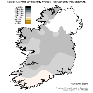
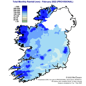
Rainfall: Above average nearly everywhere, wettest in the Northwest
Nearly all rainfall totals were above their Long-Term Average (LTA) for the month. Percentage of monthly rainfall values ranged from 100% (monthly rainfall total of 101.4 mm) at Sherkin Island, Co Cork to 206% at both Casement Aerodrome, Co Dublin (monthly rainfall total of 99.9 mm) and Newport, Co Mayo (the highest monthly total of 260.4 mm). Monthly rainfall totals were lowest at Oak Park, Co Carlow with 82.5 mm (144% of its LTA). The month’s wettest day was also recorded at Newport, Co Mayo with 32.3 mm on Saturday 19th. The number of rain days ranged from 21 days at Johnstown Castle, Co Wexford to 28 days at a few stations. The number of wet days1 ranged from 14 days at Johnstown Castle, Co Wexford to 26 days at Belmullet, Co Mayo. The number of very wet days3 ranged from 1 day at Moore Park, Co Cork to 10 days at Newport, Co Mayo.
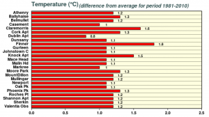
Temperature: Above average everywhere
All mean air temperatures across the country were above their Long-Term Average (LTA) for the month. Deviations from mean air temperature ranged from 0.9 °C (6.4 °C mean temperature) at Markree, Co Sligo to 1.8 °C (7.1 °C mean temperature) at Phoenix Park, Co Dublin. Mean temperatures for the month ranged from 5.5 °C (1.3 °C above its LTA) at Knock Airport, Co Mayo to 8.8 °C (1.3 °C above its LTA) at Sherkin Island, Co Cork. The month’s highest temperature was reported at Moore Park, Co Cork on Wednesday 16th with a temperature of 15.3 °C (its highest maximum temp for February since 2012). Both the month’s lowest air and grass minimum temperature were recorded on Friday 11th at Mullingar, Co Westmeath. The lowest air minimum was -2.6 °C while the lowest grass minimum was -8.4 °C. More than half of stations reported ground frost. The number of days with ground frost ranged from zero days at Belmullet, Co Mayo to 16 days at Mount Dillon, Co Roscommon. More than half of stations reported air frost. The number of days with air frost ranged from zero days at Mace Head, Co Galway to 5 days at both Moore Park, Co Cork and Mullingar, Co Westmeath.
Sunshine: Sunny in the South, dull elsewhere
Percentage of Long-Term Average (LTA) sunshine values were variable across the country. Percentage of monthly sunshine values ranged from 94% (monthly sunshine total of 66.6 hours) at Casement Aerodrome, Co Dublin to 109% (monthly sunshine total of 71.4 hours) at Shannon Airport, Co Clare. Monthly sunshine totals were highest at Johnstown Castle, Co Wexford with 86.2 hours (No LTA comparison*). Monthly sunshine totals were lowest at Ma-lin Head, Co Donegal with 45.5 hours (No LTA comparison*). The highest number of daily sunshine hours recorded this month was 8.5 hours at Johnstown Castle, Co Wexford on Friday 25th. The number of dull days2 ranged from 5 days at Cork Airport to 12 days at Belmullet, Co Mayo.
Wind: Violent storm force winds reported during storm Eunice
Monthly mean wind speeds ranged from 8.7 knots (16.1 km/h) at Moore Park, Co Cork to 22.6 knots (41.9 km/h) at Mace Head, Co Galway. Gales were reported on numerous days with up to strong gales reported on the 6th, 16th, 17th, 18th, 20th, 21st, and 24th. Storm force winds were reported on Sunday 20th and Monday 21st during storm Franklin. Violent storm force winds were reported on Friday 18th during storm Eunice. The number of days with gales ranged from zero days at a few stations to 15 days at Mace Head, Co Galway. The number of days with up to strong gales ranged from zero at a few stations to 6 days at Mace Head, Co Galway. The number of days with up to storm force winds ranged to zero days at most stations to two days at both Malin Head, Co Donegal and Mace Head Co Galway. There was one day with violent storm force winds at Roches Point, Co Cork during storm Eunice. The month’s highest gust was reported at Mace Head, Co Galway on the 20th Feb with 75 knots (138 km/h). The month’s highest 10-minute mean wind speed was 57 knots (105 km/h) at Roche’s Point, Co Cork on the 18th.
The full report is available here

Rainfall % of 1981 – 2021 Monthly Average for February 2022 (Provisional)

Total Monthly Rainfall (mm) for February 2022 (Provisional)


