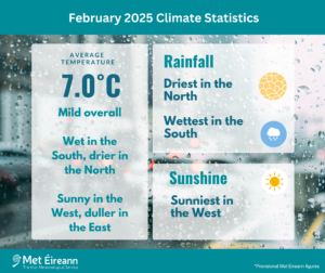
Mild. Wet in the South, drier in the North. Sunny in the West, duller in the East
- The average national temperature for February 2025 (using the Island of Ireland dataset*) was 7.02 °C, which is 1.02 °C above the most recent 1991-2020 long-term average (LTA) and 1.89 °C above the 1961-1990 LTA. February 2025 was the 16th warmest on record since 1900.
- The warmest February remains in 1998 (27 years ago) with an average temperature of 8.50°C and the coldest February remains in 1947 (78 years ago) with an average temperature of 1.06°C.
- Provisional gridded rainfall data suggests February 2025 averaged at 129.8 mm (122% of the 1991-2020 LTA or 135% of the 1981-2010 LTA).
- The wettest February was in 2020 (5 years ago) and the driest January was in 1986 (39 years ago).
February 2025 Climate Statistics
February 2025 was mild overall. Rainfall varied between wet in the South to relatively dry in parts of the Midlands and North. The first week began mild with low pressure to the northwest and high pressure to the south. Several weather fronts crossed the country in a south-westerly airflow bringing spells of rain, heaviest in the South and West. It became drier during the second half of the first week as high pressure initially built north over Ireland and then moved towards southern Scandinavia. This introduced a colder and cloudier easterly airflow over Ireland that stayed in place for most of the second week. The blocking high pressure over Scandinavia kept it mostly dry for the first half of the second week. However, during the second half of the week, as the winds turned more south-easterly, weather fronts gradually encroached from the south and west and brought some rain at times, along with a lot of cloud. During the third week Ireland lay between high pressure to the east and low pressure to the west in a south-easterly airflow, which gradually became more south-westerly and milder as the week progressed. This brought a lot of cloud and some rain at times, which became heavier as the week progressed, especially in the South. The fourth week was dominated by Atlantic westerlies as the jet stream became more active. Low pressure systems passed to the north of Ireland and brought bands of rain or showers along with strong winds at times, interspersed with drier and sunnier periods. The month finished drier as high pressure built north over Ireland again.
Rainfall: Wettest in the South, driest in the North
The majority of monthly rainfall totals were above their 1991-2020 Long-Term Average (LTA). Percentage of monthly rainfall values ranged from 66% (63.2 mm) at Malin Head, Co Donegal to 220% (213.4 mm) at Cork Airport, Co Cork. Monthly rainfall totals ranged from 48.3 mm (92% of its LTA) at Dublin Airport, Co Dublin to 213.4 mm (220% of its LTA) at Cork Airport, Co Cork (its 7th wettest February on record (length 64 years)). The month’s wettest day was also recorded at Cork Airport with 36.6 mm on Sunday 23rd. The number of rain days* ranged from 15 days at Dunsany, Co Meath to 24 days at Knock Airport, Co Mayo. The number of wet days* ranged from 11 days at a few stations to 20 days at Belmullet, Co Mayo. The number of very wet days* ranged from zero days at Dublin Airport to 8 days at both Valentia Observatory, Co Kerry and Cork Airport, Co Cork.
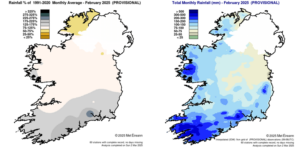
Rainfall % of 1991 – 2020 Monthly Average for February 2025 (Provisional) Total Monthly Rainfall (mm) for February 2025 (Provisional)
Temperature: Above average everywhere
All mean air temperatures across the country were above their LTA for the month. Deviations from mean air temperature ranged from +0.6 °C (7.3 °C mean temperature) at Belmullet, Co Mayo to +1.4 °C at Valentia Observatory, Co Kerry (8.8 °C mean temperature). Mean temperatures for the month ranged from 5.2 °C (0.7 °C above its LTA) at Knock Airport, Co Mayo 8.8 °C (1.4 °C above its LTA) at Valentia Observatory, Co Kerry. The month’s highest temperature was reported at Moore Park, Co Cork on Thursday 20th with a temperature of 14.8 °C. The month’s lowest air and grass minimum were recorded at Mount Dillon, Co Roscommon with the lowest air temperature reported on Thursday 6th with -5.2 °C while the lowest grass minimum was -10.2 °C reported on Friday 7th. All stations reported ground frost during the month. The number of days with ground frost ranged from 5 days at Mace Head, Co Galway to 13 days at both Mount Dillon, Co Roscommon and Claremorris, Co Mayo. More than half of stations reported air frost. The number of days with air frost ranged from zero days at a few stations to 7 days at Markree, Co Sligo.
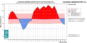
Valencia Observatory, Co Kerry Temperature: Daily mean departure from LTA for February 2025 based on 09-09hr Max/Min values.
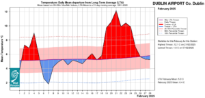
Dublin Airport, Co Dublin Temperature: Daily mean departure from LTA for February 2025 based on 09-09hr Max/Min values.
Sunshine: Sunny in the West, duller in the East
Nearly all available sunshine totals were above their LTA. Percentage of monthly sunshine values ranged from 98% (the month’s lowest sunshine total of 73.7 hours) at Casement Aerodrome, Co Dublin to 134% (92.6 hours) at Shannon Airport, Co Clare. Monthly sunshine totals were highest at Belmullet, Co Mayo with 97.3 hours (no LTA comparison*). The highest number of daily sunshine hours recorded this month was 9.6 hours at Gurteen, Co Tipperary on Thursday 27th. The number of dull days* ranged from 7 days at Belmullet, Co Mayo to 14 days at Johnstown Castle, Co Wexford. Dublin Airport, Co Dublin saw 11 consecutive days without sunshine (0.0 hours) between Saturday 8th and Tuesday 18th. This ties the record for consecutive sunless days at Dublin Airport (previously occurred in March 1969).
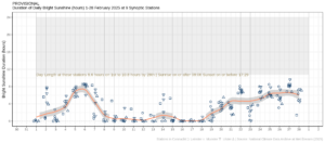
Hours of Bright Sunshine observed at nine stations for each day of the month of February 2025, grouped by province relative to the highest number of hours possible by end of month (shaded box).
Wind: Strong gales reported
Monthly mean wind speeds ranged from 7.6 knots (14.1 km/h) at Moore Park, Co Cork and Mount Dillon, Co Roscommon to 17.7 knots (32.8 km/h) at Malin Head, Co Donegal. Gales were reported on the 1st, 3rd, 20th, 21st, 23rd and 26th with up to strong gale winds reported on Sunday 23rd. The number of days with gales ranged from zero days at a few stations to 5 days at Belmullet, Co Mayo. The number of days with up to strong gales ranged from zero at most stations to 1 day at Roche’s Point, Co Cork and Belmullet, Co Mayo, both on Sunday 23rd. The month’s highest gust was reported at Valentia Observatory, Co Kerry on Thursday 20th with 59 knots (109 km/h). The month’s highest 10-minute mean wind speed was 44 knots (82 km/h) at Belmullet, Co Mayo on Sunday 23rd.
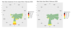
Wind roses for February 2025, sustained 10-min mean and gust.
The full report is available here.
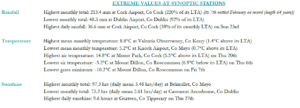
Extreme values for February 2025 at synoptic stations
*Issued by Met Éireann on Tuesday 4th March 2025. This report is based on available preliminary data from 25 principal weather stations operated by Met Éireann. Synoptic station data is midnight to midnight UTC. Long-Term Averages (LTAs) and “average” refer to the period 1991-2020 unless stated. A rain day is a day on which 0.2 mm or more of rainfall is measured. A wet day is a day with 1.0 mm or more of rainfall. A dull day is a day with less than 0.5 hours of sunshine. A very wet day is a day with 10.0 mm or more of rainfall. Climatological dry periods – An absolute drought is a period of 15 or more consecutive days to none of which is credited 0.2 mm or more of precipitation. A partial drought is a period of at least 29 consecutive days, the mean daily rainfall of which does not exceed 0.2 mm. A dry spell is a period of 15 or more consecutive days to none of which is credited 1.0 mm or more of precipitation (i.e. daily tot < 1.0 mm). A heatwave occurs where there are 5 consecutive days or more with maximum temperature over 25°C (that is, a daily maximum screen air temperature > 25° C). The ‘Island of Ireland’ dataset is 125 years long and runs between 1900 and 2023. For this dataset the long term averages from the 1961-1990 reference period are used for comparison as is standard for long-term climate change assessments. *Sunshine data is from the Autosol Network. LTAs for these sites are currently not used for comparison purposes. For more information, contact Met Éireann at 01-8064200 or e-mail: enq@met.ie