Cool and dry overall
- The average national temperature for September 2024 (using the Island of Ireland dataset*) was 13.18 °C, which is 0.42 °C below the most recent 1991-2020 long-term average (LTA) and 0.22 °C below the 1981-2010 LTA. However, average national temperature for September 2024 is 0.23 °C above the 1961-1990 LTA.
- September 2024 was the coldest September in 6 years, since September 2018.
- The warmest September on record was in 2021 with an average temperature of 15.27 °C and the coldest September was in 1918 with an average temperature of 10.94 °C.
- Provisional gridded rainfall data suggests September 2024 averaged at 63.6 mm, the second driest month of the year so far behind June 2024 (20.8 mm) and the 14th driest September since 1941.
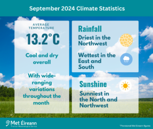
September 2024 Climate Statistics
September 2024 was cool and dry overall, however, conditions varied considerably throughout the month and from region to region. The North and West saw the sunniest and driest conditions with high pressure to the north dominating, while the South and East saw more rain, wind and cloud with low pressure to the south dominating. The month began with frontal rain encroaching from the east before Atlantic fronts introduced a cooler polar maritime air mass with showers for a few days. High pressure built to the north of Ireland towards the end of the first week, while low pressure over mainland Europe steered a very warm tropical continental air mass over the country from the east. This brought the warmest period of the month for many on Friday 6th and Saturday 7th. The second week saw high pressure to the west and low pressure over Scandinavia steering a cooler polar maritime air mass south over the country, with rain or showers at times and the first air frost of autumn on Friday 13th at Mount Dillon, Co Roscommon. The third week saw high pressure build over Ireland and move slowly to the north. This brought warm, dry and sunny conditions between Monday 16th and Friday 20th, is a mostly light easterly airflow. The final third of the month was cool and dominated by low pressure to the south. Two deep Atlantic low pressure systems passed close to the south of the country and brought spells of wet and windy weather. The first on Wednesday 25th and Thursday 26th and the second on Sunday 29th and Monday 30th, with the bulk of the rain falling in the South and East.
Rainfall: Driest in the Northwest, wettest in the East and South
Nearly all rainfall totals were below their 1981-2010 Long-Term Average (LTA) for the month. Percentage of monthly rainfall values ranged from 15% (the month’s lowest monthly rainfall total of 17.2 mm) at Mace Head, Co Galway (its driest September since 2014) to 124% (the month’s highest monthly rainfall total of 108.4 mm) at Johnstown Castle, Co Wexford. The highest daily rainfall total was 51.3 mm at Cork Airport, Co Cork on Sunday 29th (its highest daily fall in September since 1965). The number of rain days* ranged from 10 days at Sherkin Island, Co Cork to 20 days at Knock Airport, Co Mayo. The number of wet days* ranged from 5 days at Mace Head, Co Galway to 15 days at both Newport, Co Mayo and Knock Airport, Co Mayo. The number of very wet days* ranged from zero days at seven stations in the West and Northwest to 3 days at four stations in the South and East. Nine stations, mostly in the West and Northwest, had their driest September since 2014. There were eight consecutive dry days (0.0 mm) from Monday 16th to Monday 23rd, at Markree Castle, Co Sligo, Malin Head, Co Donegal and Valentia Observatory, Co Kerry.
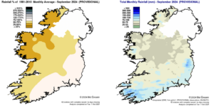
Rainfall % of 1981 – 2010 Monthly Average for September 2024 (Provisional) Total Monthly Rainfall (mm) for September 2024 (Provisional)
Temperature: Coolest in the East, warmest in the Southwest
The majority of mean air temperatures across the country were below their LTA for the month. Deviations from mean air temperature ranged from -0.9 °C at both Dunsany, Co Meath (12.1 °C mean temperature) and Dublin Airport, Co Dublin (12.2 °C mean temperature) to 0.2 °C at Roche’s Point, Co Cork (14.1 °C mean temperature). Mean temperatures for the month ranged from 12.0 °C (at its LTA) at Knock Airport, Co Mayo to 14.3 °C (at its LTA) at Sherkin Island, Co Cork. The month’s highest temperature was reported at Claremorris, Co Mayo on Friday 6th with a temperature of 25.2 °C. The month’s lowest air minimum was recorded on Friday 13th at Mount Dillon, Co Roscommon with -0.8 °C, the earliest First Autumn Frost in 32 years. The lowest grass minimum was -3.1 °C reported at Dublin Airport, Co Dublin on Friday 13th and Markree, Co Sligo on Wednesday 25th. More than half of stations reported ground frost. The number of days with ground frost ranged from zero days at Phoenix Par, Co Dublin to 5 days at both Ballyhaise, Co Cavan and Mullingar, Co Westmeath. Two stations reported air frost. The number of days with air frost ranged from zero days at most stations 1 day at both Markree, Co Sligo and Mount Dillon, Co Roscommon. It was the coldest September since 2018 at seventeen stations and the coldest at two stations since 2015.
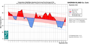
Sherkin Island, Co Cork Temperature: Daily mean departure from LTA for September 2024 based on 09-09hr Max/Min values.
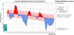
Dublin Airport, Co Dublin Temperature: Daily mean departure from LTA for September 2024 based on 09-09hr Max/Min values.
Sunshine: Sunniest in the North and Northwest
Sunshine values were variable across the country. Percentage of monthly sunshine values ranged from 95% (monthly sunshine total of 118.9 hours) at Casement Aerodrome, Co Dublin to 101% (monthly sunshine total of 119.7 hours) at Shannon Airport, Co Clare. Monthly sunshine totals ranged from 107.9 hours (No LTA comparison*) at Gurteen, Co Tipperary to 152.1 hours (No LTA comparison*) at Malin Head, Co Donegal. The highest number of daily sunshine hours recorded this month was 12.7 hours at Belmullet, Co Mayo on Thursday 5th. The number of dull days* ranged from 5 days at both Malin Head, Co Donegal and Belmullet, Co Mayo to 10 days at Dublin Airport, Co Dublin.
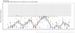
Hours of Bright Sunshine observed at nine stations for each day of the month of September 2024, grouped by province relative to the highest number of hours possible by end of month (shaded box)
Wind: Gales reported
Monthly mean wind speeds ranged from 4.8 knots (8.9 km/h) at Ballyhaise, Co Cavan to 13.7 knots (25.4 km/h) at Malin Head, Co Donegal. Gales were reported on Saturday 14th, Thursday 26th and Sunday 29th. The number of days with gale force winds ranged from zero days at most stations to 1 day at four stations in the Southwest and Northwest. There were no strong gales or storm force winds reported this month. The month’s highest gust was reported at Roche’s Point, Co Cork on Sunday 29th with 48 knots (88 km/h). The month’s highest 10-minute mean wind speed was 37 knots (68 km/h) at Malin Head, Co Donegal on Thursday 26th.
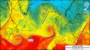
Airmass Analysis chart 06 UTC 29 September 2024: Low pressure system moving from west to east close to the south of Ireland on the day Cork Airport saw 51.3 mm of rainfall (its highest daily fall in September since 1965). Tropical system Issac stayed well away to the southwest of Ireland.
The full report is available here.
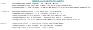
Extreme values for September 2024 at synoptic stations
First Autumn Frost of 2024 reported
The first frost of autumn 2024 was observed Friday 13th September 2024 around 5 am (04 UTC) at Mount Dillon, Co Roscommon when the minimum air temperature fell to -0.8 °C (9.0 °C below its 1991-2020 LTA). This is the second year running that Mount Dillon recorded the first frost. The first frost of 2023 occurred on Thursday 12th October 2023.
- This was the earliest first autumn frost in 32 years.
- The last frost of Spring 2024 was observed on Sunday 28th April 2024 when air temperatures fell below zero degrees at many of the 25 principal weather stations.
- The lowest minimum air temperature of 2024 so far at a principal weather station is – 7.3°C at Athenry, Co Galway on Thursday 18th January 2024.
*Issued by Met Éireann on Wednesday 2nd October 2024. This report is based on available preliminary data from 25 principal weather stations operated by Met Éireann. Synoptic station data is midnight to midnight UTC. Long-Term Averages (LTAs) and “average” refer to the period 1981-2010 unless stated. A rain day is a day on which 0.2 mm or more of rainfall is measured. A wet day is a day with 1.0 mm or more of rainfall. A dull day is a day with less than 0.5 hours of sunshine. A very wet day is a day with 10.0 mm or more of rainfall. Climatological dry periods – An absolute drought is a period of 15 or more consecutive days to none of which is credited 0.2 mm or more of precipitation. A partial drought is a period of at least 29 consecutive days, the mean daily rainfall of which does not exceed 0.2 mm. A dry spell is a period of 15 or more consecutive days to none of which is credited 1.0 mm or more of precipitation (i.e. daily tot < 1.0 mm). A heatwave occurs where there are 5 consecutive days or more with maximum temperature over 25°C (that is, a daily maximum screen air temperature > 25° C). The Island of Ireland dataset is 125 years long and runs between 1900 and 2023. For this dataset the long term averages from the 1961-1990 reference period are used for comparison as is standard for long-term climate change assessments. *Sunshine data is from the Autosol Network. LTAs for these sites are currently not used for comparison purposes. For more information, contact Met Éireann at 01-8064200 or e-mail: enq@met.ie