Mild December and February, cool January. Wet in the South, dry elsewhere
- Overall (using the Island of Ireland dataset*), the average national temperature for winter 2024/25 was 6.73 °C, which is 0.73 °C above the most recent 1991-2020 long-term average (LTA) for winter and 1.36 °C above the 1961-1990 LTA for winter.
- Winter 2024/25 was the 15th warmest winter since 1900. The warmest winter was in 2019 with 7.48 °C and the coldest winter was in 1963 with 2.90 °C.
- Provisional gridded rainfall data suggests winter 2024/25 was the 41st driest winter since 1940, with 95% of the 1991-2020 LTA or 102% of the 1981-2010 LTA. The driest winter was in 1964 and the wettest was in 2016.
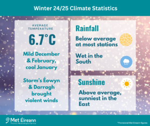
Winter 2024/25 Climate Statistics
Winter 2024/25 was a mild winter overall with both December and February seeing above average temperatures at all stations. January saw below average temperatures at most stations, due to a cold Arctic airmass descending over Ireland from the north during the first third of the month. Pressure was higher than average through most of December, which led to drier than average conditions overall, but often quite cloudy. Storm Darragh, named by the Met Office (UK), crossed over the northern half of the country late on Friday 6th and early Saturday 7th December and brought the strongest winds of 2024. Rainfall varied during January from dry in the North and Northwest to progressively wetter towards the South and East. It was quite a sunny month overall. The cold airmass over Ireland early in the month brought heavy snow to the south Midlands, South, Southwest and West, which stayed on the ground for several days in places. Storm Éowyn, named by the Met Office (UK), reached peak intensity as it brushed by the northwest coast of Ireland in the early hours of Friday 24th January and brought extreme winds across the country with widespread disruption and power outages. Rainfall during February varied between wet in the South to relatively dry in parts of the Midlands and North. There was a prolonged period of easterly winds during the middle of the month due to blocking high pressure over Scandinavia, which brought a lot of cloud, but the month finished sunny.
Rainfall: Below average at most stations, above average in the South
The majority of seasonal rainfall totals across the country were below their 1991-2020 Long-Term Average (LTA). Percentage of seasonal rainfall values ranged from 67% (232.7 mm) at Athenry, Co Galway to 127% (352.9 mm) at Roches Point, Co Cork. Seasonal rainfall totals ranged from 167.1 mm (90% of its LTA) at Dublin Airport, Co Dublin to 532.5 mm (106% of its LTA) at Valentia Observatory, Co Kerry. The season’s wettest day was also recorded at Valentia Observatory, Co Kerry with 37.4 mm on Saturday 4th January. The number of rain days* ranged from 45 days at Dublin Airport to 76 days at both Belmullet, Co Mayo and Knock Airport, Co Mayo. The number of wet days* ranged from 30 days at Casement Aerodrome, Co Dublin to 62 days at a few stations. The number of very wet days* ranged from 2 days at Dunsany, Co Meath to 21 days at Valentia Observatory, Co Kerry. A Dry spell* was recorded at Phoenix Park, Co Dublin between Monday 6th January and Wednesday 22nd January (17 days).
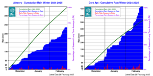
Athenry, Co Galway – Cumulative Rain Winter 2024-2025 Cork Airport, Co Cork- Cumulative Rain Winter 2024-2025
Temperature: Above average everywhere
All mean air temperatures across the country were above their LTA for the season. Deviations from mean air temperature ranged from 0.3 °C (6.7 °C mean temperature) at Johnstown Castle, Co Wexford to 0.8 °C (7.1 °C mean temperature) at Malin Head, Co Donegal. Mean temperatures for the season ranged from 5.1 °C (0.7 °C above its LTA) at Knock Airport, Co Mayo to 8.5 °C (0.6 °C above its LTA) at Sherkin Island, Co Cork. The season’s lowest temperatures were recorded on Thursday 9th January with the lowest air minimum reported at Athenry, Co Galway with a temperature of -7.6 °C and the lowest grass minimum reported at Mullingar, Co Westmeath with -11.8 °C. The highest maximum was reported on Tuesday 17th December at Shannon Airport, Co Clare with a temperature of 15.0 °C. All stations reported air and ground frost during the season. The number of days with ground frost ranged from 19 days at Sherkin Island, Co Cork to 50 days at Phoenix Park, Co Dublin. The number of days with air frost ranged from 1 day at a few stations to 28 days at Athenry, Co Galway. Oak Park, Co Carlow with –6.7 °C had its lowest winter temperature since winter 2010/11. Nine stations reported an icing day* on Wednesday 8th January.
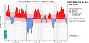
Sherkin Island, Co Cork Temperature: Daily mean departure from LTA for Winter 2024-2025 based on 09-09hr Max/Min values

Dublin Airport, Co Dublin Temperature: Daily mean departure from LTA for Winter 2024-2025 based on 09-09hr Max/Min values
Sunshine: Above average, sunniest in the East
All available sunshine totals were above their LTA for the season. Percentage of seasonal sunshine values ranged from 108% (190.6 hours) at Casement Aerodrome, Co Dublin to 119% (199.4 hours) at Shannon Airport, Co Clare. Seasonal sunshine totals ranged from 156.6 hours (No LTA comparison*) at Malin Head, Co Donegal to 209.9 hours (No LTA comparison*) at Dublin Airport, Co Dublin. The highest number of daily sunshine hours recorded this season was 9.6 hours at Gurteen, Co Tipperary on Thursday 27th February. The number of dull days* ranged from 35 days at Valentia Observatory, Co Kerry to 46 days at Johnstown Castle, Co Wexford.
Wind: Storm Éowyn brought hurricane force winds and storm Darragh brought violent storm force winds
Seasonal mean wind speeds ranged from 6.5 knots (12.0 km/h) at Moore Park, Co Cork to 17.2 knots (31.9 km/h) at Malin Head, Co Donegal. Gales were reported on numerous days with strong gales reported on the 6th, 7th, 19th, 21st and 22nd December, 23rd, 24th, 26th and 27th January and 23rd February. Storm force winds were reported on Friday 6th and Saturday 7th December during storm Darragh and on Sunday 22nd December. Storm force winds were also reported on Thursday 23rd and Friday 24th January during storm Éowyn. Mean wind speeds reached violent storm force 11 on Friday 6th December during storm Darragh. Mean wind speeds reached violent storm force 11 and hurricane force 12 on Friday 24th during storm Éowyn. The number of days with gales ranged from zero days at a few stations to 19 days at Malin Head, Co Donegal. The number of days with up to strong gales ranged from zero at a few stations to 6 days at both Roches Point, Co Cork and Malin Head, Co Donegal. Both the season’s highest gust and 10-minute mean wind speed was reported at Mace Head, Co Galway on Friday 24th January. The highest gust was 99.5 knots (184 km/h) while the month’s highest 10-minute mean wind speed was 76.5 knots (142 km/h) (Ireland’s highest provisional (sustained and gust) wind speeds in the digital climate record).
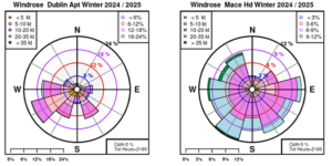
Dublin Airport, Co Dublin and Mace Head, Co Galway: Wind Roses for Winter 2024-2025
The full report is available here (choose Winter on drop down menu for month) or the PDF is available here
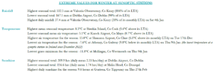
Winter 2024-2025 extreme values at synoptic stations
*Issued by Met Éireann on Wednesday 5th March 2025. This report is based on available preliminary data from 25 principal weather stations operated by Met Éireann. Synoptic station data is midnight to midnight UTC. Long-Term Averages (LTAs) and “average” refer to the period 1991-2020 unless stated. A rain day is a day on which 0.2 mm or more of rainfall is measured. A wet day is a day with 1.0 mm or more of rainfall. A dull day is a day with less than 0.5 hours of sunshine. A very wet day is a day with 10.0 mm or more of rainfall. Climatological dry periods – An absolute drought is a period of 15 or more consecutive days to none of which is credited 0.2 mm or more of precipitation. A partial drought is a period of at least 29 consecutive days, the mean daily rainfall of which does not exceed 0.2 mm. A dry spell is a period of 15 or more consecutive days to none of which is credited 1.0 mm or more of precipitation (i.e. daily tot < 1.0 mm). A heatwave occurs where there are 5 consecutive days or more with maximum temperature over 25°C (that is, a daily maximum screen air temperature > 25° C). The ‘Island of Ireland’ dataset is 125 years long and runs between 1900 and 2023. For this dataset the long term averages from the 1961-1990 reference period are used for comparison as is standard for long-term climate change assessments. *Sunshine data is from the Autosol Network. LTAs for these sites are currently not used for comparison purposes. For more information, contact Met Éireann at 01-8064200 or e-mail: enquiries@met.ie