Réamhaisnéis limistear na farraige
Forecast valid from: 06:00, Tuesday 28 April 2026 until 06:00, Wednesday 29 April 2026
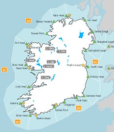
Small Craft Warning
East to northeast winds will increase forcce 6 tomorrow morning on Irish coasts from Carnsore Point to Hook Head to Roches Point.
Gale Warning
Nil
Meteorological Situation at 03:00 UTC
Ireland lies in a light to moderate northerly airflow with a broad area of high pressure of 1034hPa centred over Scandinavia and extending across Ireland.
Small Craft Warning: In effect
Heavy Swell (>4m) : No
Forecast for Belfast Lough to Wicklow Head to Valentia and for the Irish Sea
Wind: East to northeast force 3 to 5, increasing force 4 to 6 by the end of the period.
Weather: Cloudy to fair with a chance of isolated showers. Later becoming fine or fair. Mist and fog patches possible.
Visibility: Good, decreasing moderate or poor in any showers, mist and fog.
Forecast for Valentia to Erris Head to Belfast Lough
Wind: Northeasterly force 2 to 4, later becoming easterly force 3 or 4.
Weather: Cloudy to fair with a chance of isolated showers. Later becoming fine or fair. Mist and fog patches possible.
Visibility: Good, decreasing moderate or poor in any showers, mist and fog.
Outlook for a further 24 hours until 06:00, Thursday 30 April 2026
Moderate to strong east to northeast winds, possibly reaching near gale force in the south on Wednesday night. Weather: Fair with isolated mist and fog patches possible. Becoming cloudy in the west and south on Wednesday night with outbreaks of rain developing.
Forecast issued at: 06:00, Tuesday 28 April 2026
All times are local unless specified