The following information is valid at 15:30, Friday 4th October 2024 until further updates.
The meteorological situation described yesterday (below) is still valid, with a band of rain expected to trail over the country from Friday night (4th October) through to Saturday night (5th October), with the heaviest and most persistent rain forecast over the southwest and west of the country, particularly over counties Kerry and Cork.
The low pressure system will be slow moving and updates from our models this morning have led to a revision of the warnings issued yesterday. The orange rainfall warnings for Kerry and Cork have been extended for an additional hour to midnight on Saturday (valid from 00:00 Saturday 5th to 00:00 Sunday 6th). Waterford has also been elevated to an orange rainfall warning, valid from 12:00 Saturday to 00:00 Sunday. This is due to a combination of factors: heavy rainfall in mountainous regions, soil conditions which have not recovered from last weekend’s rainfall and the heaviest of the rain coinciding with high tide. All this coupled with fresh to strong onshore winds which will exacerbate river levels.
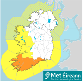
Figure 1 – Rainfall warnings issued by Met Éireann for Saturday 5th October (valid at time of writing on Friday 4th October)
Accumulations of 30-50 mm over 24h are likely in the counties under yellow warning, however rainfall amounts may be higher on windward slopes of the mountains in west Galway and west Mayo. Parts of Cork, Kerry and Waterford will see totals of 50-70 mm over a 24h period, but similarly, higher accumulations can be expected in mountainous regions of west Kerry and west Cork.
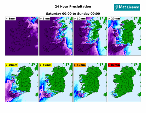
Figure 2 –24 Hour Precipitation Ensemble Forecast Probability Maps, available to the public here ( 24 Hour Precipitation – Met Éireann – The Irish Meteorological Service). The image shows the probability of rainfall accumulations over certain thresholds for this Saturday 5th October to Sunday 6th October.
In view of this, updates to potential impacts expected are:
- River flooding: Soils are saturated in some places and river levels are currently low but will respond notably to the amount of rain, with out of bank flooding expected in places. Smaller rivers, especially those prone to flash flooding in urban and upland areas, may rise quickly on Saturday and into Sunday. Rivers in the south and west, particularly in the mountainous areas of Kerry, West Cork and Limerick, as well as Galway and Mayo could be affected. Given the volume of rainfall forecast throughout the weekend, levels will potentially rise in the headwaters of larger rivers including the Lee, Munster Blackwater and Bandon. It’s important to note that rivers are likely to continue to respond and rise over the weekend and into next week with further rain expected.
- Coastal flooding: We are in a period of Spring tides, although not a particularly high Spring tide. Onshore winds Saturday evening on the south coast may coincide with high tide (approx. 18:00-20:00), exacerbating rising river levels in estuarine areas, resulting in flooding. Strong onshore winds may lead to wave overtopping in exposed coastal areas.
- Dangerous travelling conditions due to low visibility, surface water and potentially flooding.
- Travel disruptions.
Please keep in touch with Met Éireann’s social media channels, www.met.ie and the Met Éireann app to stay up to date with the forecast and any updates to the warnings.
The timing and location of weather can significantly affect its impact. It’s important to note that in any individual weather event, not every location within a warning area may experience the same degree of weather or impacts.
When severe weather is expected, weather and impacts at lower levels are also likely to be experienced. The type and degree of impacts can be strongly affected by previous weather conditions. Met Éireann takes into consideration the forecasted conditions and thresholds, as well as previous weather conditions, that may increase the level of impact expected for particular areas when issuing a warning.
WHAT SHOULD YOU DO PRIOR TO AND DURING EXTREME WEATHER? PUBLIC SAFETY INFORMATION AND MESSAGES FROM EMERGENCY MANAGEMENT STAKEHOLDERS
- Stay up-to date with the forecast and the warnings for your county on met.ie, the Met Éireann app or Met Éireann socials (@meteireann).
- Check in with your local authority and emergency management stakeholders (Irish Coast Guards, Gardaí, etc) through their website and social channels to see how your area will be/is affected.
- Ensure your mobile is phone is fully charged to enable communication in advance of the event and keep local emergency numbers in your phone.
- Keep a small amount of food, extra medical and water supplies in case it’s dangerous to step out of the home.
- “Be Winter Ready”: Follow recommendations before, during and after the event on ie – Be Winter Ready (www.gov.ie)
- Advance planning for flooding: You can consult the OPW flood maps, which show areas that may be at risk of flooding, based on historical data (see www.floodinfo.ie).
- Stay away from coastal areas during the period. Remember the advice from the Irish Coast Guard: “Stay Back, Stay High, Stay Dry”.
- Don’t try to walk, cycle or drive through flooded areas, the depth of the water can be deceiving.
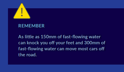
- Remember: As little as 150mm of fast-flowing water can knock you off your feet and 300mm of fast-flowing water can move most cars off the road.

- ESB Networks is highlighting the dangers posed by fallen live wires and advises the public and the emergency services to stay away from fallen cables and to report such cases immediately. ESB Emergency Services can be contacted at 1800 372 999.
- You can monitor powercheck.ie in regard to power restoration times.
____________________________________________________________________________________
METEOROLOGICAL SITUATION
The following information is valid at 18:00, Thursday 3rd October 2024 until further updates.
Through Friday night (4th October) and into Saturday (5th October) a broad area of low pressure will move over Ireland introducing a milder and moist airmass. The progression of this system across Ireland will be stalled due to high pressure over central Europe. A band of rain associated with this system is expected to trail over the country through Saturday 5th October, with the heaviest and most persistent rain forecast over the southwestern and west of the country, particularly over counties Kerry and Cork.
Figure 1 – Rainfall forecast for Friday (4th October) to Sunday (6th October)
Deputy Head of Forecasting Liz Coleman said: “Friday will be a cloudy and damp day with rain and drizzle in many areas, but the impactful rain will start from Friday night onwards and the rain will be heavy and persistent in many areas for much of Saturday.
Through Saturday, high pressure in the mid-Atlantic, together with an area of low-pressure further north, will work in tandem to drag warm tropical air up over the country. As we know, the warmer the air, the higher its ability to hold moisture, so this event has the potential to be quite impactful.”
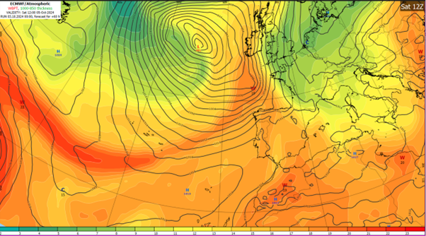
Figure 2 – Airmass Temperature and Surface Pressure chart, showing area of low-pressure (L) to the west of Ireland, working in tandem with an area of high-pressure (H) in the mid-Atlantic, which has its origin over warm seas in the tropics (dark orange and red airmass)
Liz Coleman continues: “While much of the west and southwest are forecast to receive over 30mm of rain in a 24h period, our models are currently predicting in excess of 50mm of rain over parts of southwest Kerry and west Cork, with higher accumulations possible in mountainous areas.”
![]()
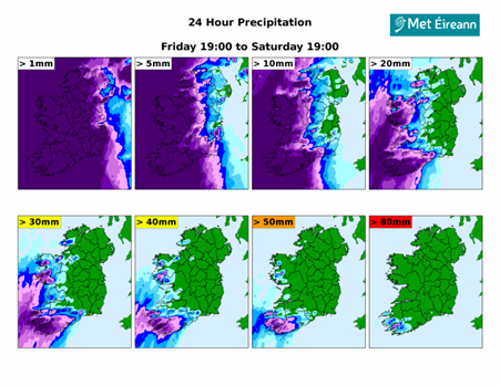
Figure 3 –24 Hour Precipitation Ensemble Forecast Probability Maps, available to the public here ( 24 Hour Precipitation – Met Éireann – The Irish Meteorological Service). The image shows the probability of rainfall accumulations over certain thresholds for this Friday 4th October and Saturday 5th October.
At the time of writing, Met Éireann has issued an ORANGE rainfall warning for counties Cork and Kerry (Valid: 00:00 to 23:00 Saturday 05/10/2024) and a YELLOW rainfall warning for counties Clare, Limerick, Waterford, Galway and Mayo (Valid: 00:00 Saturday 05/10/2024 to 00:00 Sunday 06/10/2024).
In view of the situation, potential impacts expected are:
- River flooding: Although river levels are generally low, soils are currently nearing saturation. Therefore, given the widespread and prolonged nature of the rain, significant river level increases are expected, with small and upland catchments at the greatest risk of flooding.
- Coastal flooding: Fresh to strong southeasterly onshore winds and waves, coinciding with high tide along southern coasts on Saturday evening, could result in wave overtopping. Spring tides may prevent rivers from discharging into the sea at time of high tide, increasing the risk of flooding on coastal areas.
- Dangerous travelling conditions due to low visibility, surface water and potentially flooding.
- Travel disruptions.
The warnings are likely to be updated. Please keep in touch with Met Éireann’s social media channels, www.met.ie and the Met Éireann app to stay up to date with the forecast and any warnings’ updates.
The timing and location of weather can significantly affect its impact. It’s important to note that in any individual weather event, not every location within a warning area may experience the same degree of weather or impacts.
When severe weather is expected, weather and impacts at lower levels are also likely to be experienced. The type and degree of impacts can be strongly affected by previous weather conditions. Met Éireann takes into consideration the forecasted conditions and thresholds, as well as previous weather conditions, that may increase the level of impact expected for particular areas when issuing a warning.
WHAT SHOULD YOU DO PRIOR TO AND DURING EXTREME WEATHER? PUBLIC SAFETY INFORMATION AND MESSAGES FROM EMERGENCY MANAGEMENT STAKEHOLDERS
- Stay up-to date with the forecast and the warnings for your county on met.ie, the Met Éireann app or Met Éireann socials (@meteireann).
- Check in with your local authority and emergency management stakeholders (Irish Coast Guards, Gardaí, etc) through their website and social channels to see how your area will be/is affected.
- Ensure your mobile is phone is fully charged to enable communication in advance of the event and keep local emergency numbers in your phone.
- Keep a small amount of food, extra medical and water supplies in case it’s dangerous to step out of the home.
- “Be Winter Ready”: Follow recommendations before, during and after the event on ie – Be Winter Ready (www.gov.ie)
- Advance planning for flooding: You can consult the OPW flood maps, which show areas that may be at risk of flooding, based on historical data (see www.floodinfo.ie).
- Stay away from coastal areas during the period. Remember the advice from the Irish Coast Guard: “Stay Back, Stay High, Stay Dry”.
- ESB Networks is highlighting the dangers posed by fallen live wires and advises the public and the emergency services to stay away from fallen cables and to report such cases immediately. ESB Emergency Services can be contacted at 1800 372 999.
- You can monitor powercheck.ie in regard to power restoration times.