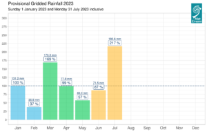
Following on from the warmest June on record for Ireland, July 2023 is set to be the wettest July on record according to provisional* data.
Provisional data from our gridded data set back to 1940 suggests:
- Ireland had 217 % of its 1981-2010 Long term Average (LTA) rainfall in July 2023.
- July 2023 also had more than 4 times the amount of rain observed in July 2022 and more than twice that observed in July 2021.
- The previous wettest July was in 2009 with 202 % of the LTA.
- Over the past 12 months, Ireland had its wettest October on record in 2022, its wettest March on record earlier this year and now its wettest July on record.
Provisional monthly records from our 25 primary weather stations suggest:
Seventeen primary weather stations have had over 200% of their LTA, with twelve stations having their wettest July on record** in 2023, including:
- Phoenix Park, Co Dublin (length 82 years) with 149.1 mm (271% of its LTA)
- Shannon Airport, Co Clare (length 77 years) with 155.0 mm (235% of its LTA)
- Malin Head, Co Donegal (length 68 years) with 192.6 mm (238% of its LTA)
- Belmullet, Co Mayo (length 66 years) with 148.5 mm (187% of its LTA)
- Dunsany, Co Meath (length 59 years) with 184.5 mm (300% of its LTA)
- Moore Park, Co Cork (length 59 years) with 150.1 mm (242% of its LTA)
- Athenry, Co Galway (length 33 years) with 224.1 mm (259% of its LTA)
- Ballyhaise, Co Cavan (length 31 years) with 154.7 mm (210% of its LTA)
You can read more on these and other station records in the Past Weather and Climate Statement for July 2023 to be published the morning of Wednesday 2 August 2023 on https://www.met.ie/climate/past-weather-statements
Knock Airport, Co Mayo observed 37 consecutive Rain Days (0.2 mm or more) ending on Sunday 23 July 2023. There was also up to 15 consecutive Wet Days (1.0 mm or more) at Dunsany, Co Meath, Malin Head, Co Donegal (ended Sunday 23 July) and Claremorris, Co Mayo (ended Friday 7 July).
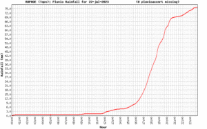
Provisionally, the highest daily rainfall total of July 2023 from our 25 primary weather stations was 41.6 mm at Dunsany, Co Meath on Saturday 22nd, followed closely by 41.2 mm at Oak Park, Co Carlow on Monday 10th. Provisionally from our automatic weather stations, Raphoe, Co Donegal had 76.4 mm of rainfall, also on Saturday 22nd, which led to flash flooding in the area. The highest daily total from the previous wettest July in 2009 was 68.5 mm at Caherkirby, Co Cork.
To find out more data about the rainfall in July 2009, visit Past Weather Statements and click the ‘Archive’ button, or view the report here.
Synoptic situation for July 2023
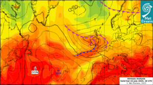
July 2023 saw Atlantic low pressure systems dominating in a mostly westerly or cyclonic airflow. Ireland lay on the cooler northern side of the North Atlantic jet stream for most of the month, which was relatively strong for the time of year. Numerous active weather fronts crossed the country along with periods of intense, sometimes thundery, convective rainfall. While Ireland experienced low pressure and cool air masses, blocking high pressure dominated southern Europe, inhibiting cloud formation and allowing extreme heat to build up. See more on the difference between Irish and European Weather in our Meteorologist’s Commentary ‘Contrasting weather across Europe – Tuesday 18 July 2023’ here.

Airmass analysis chart: Saturday 22 July. 18 UTC
Monthly forecast for August
According to Met Éireann’s latest monthly forecast, the current meteorological setup looks set to continue into the early days of August. The North Atlantic jet stream is forecast to remain south of the country, meaning it’s likely low pressure systems with associated active weather fronts will continue to dominate our weather. Our monthly forecasts are updated twice weekly, please keep up to date with the latest monthly trends and forecasts for your area on www.met.ie.
Climatological Reference Periods
Ireland’s latest 30-year climate averages for the period 1991-2020 were published this month. A comparison of the most recent 30-year period with the previous 30-year period (1961-1990), reveals a 7% increase in average annual rainfall. On a monthly basis, the greatest increase at 22% is observed in July, with most regions throughout the country observing an increase in average rainfall amounts.
Read more here: www.met.ie/climate/30-year-averages
Climate Projections
The recently published TRANSLATE climate projections, optimised for Ireland, indicate future increases in average annual temperature and rainfall, as the climate continues to warm.
Projections show more variability for summer rainfall. For global warming thresholds of 1.5-2.0°C some parts of the country are expected to experience increases in summer rainfall, while other areas may experience decreases. For global warming levels of 2.5°C upwards, projections indicate drier summers on average across the country.
Moreover, as temperature increase, we see increases in the amount of moisture held in the atmosphere, about 7% more for every 1°C of warming. As a result, we expect to see an increase in the frequency and intensity of heavy rainfall events.
In light of this, Met Éireann is committed to providing scientifically robust, reliable climate information so that we can plan for summers with record-breaking rainfall (July 2023), heat (July 2022) and everything in between.
Climatological Definitions
- A Rain Day is observed at a meteorological station when 0.2 mm or more of rain falls in a day.
- A Wet Day is observed at a meteorological station when 1.0 mm or more of rain falls in a day.
*Over the next few months, the rainfall totals from our network of voluntary observers will be returned and quality controlled, once this process is finalised, we run the analysis again, and will then confirm if July 2023 was indeed the wettest July on record (record length 83 years).
**Based on digitised data back to 1940

