Storm names increase public preparedness for extreme weather
29th August 2024: Met Éireann, along with the National Weather Services of the UK (Met Office) and the Netherlands (KNMI), has released the list of new storm names for the 2024/2025 storm season, which starts on Sunday 1st September.
Each of the three meteorological services has contributed seven names to this season’s list. Met Éireann’s contributions have been taken from a list of more than 500 suggestions by primary school children participating in ESB Science Blast last February.

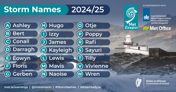
Fig 1 – Storm Names 2024/25
The full 2024/25 list is Ashley, Bert, Conall, Darragh, Éowyn, Floris, Gerben, Hugo, Izzy, James, Kayleigh, Lewis, Mavis, Naoise, Otje, Poppy, Rafi, Sayuri, Tilly, Vivienne, Wren.
(The names chosen by Met Éireann are in bold. Letters Q, U, X, Y, Z are not included, which is in line with the US National Hurricane Centre naming convention).
Eoin Sherlock, Head of Forecasting Division in Met Éireann, said:
“Our key priority is to help protect life and property from extreme weather and ensure the safety of our communities. Year after year storm naming proves effective for that. Naming each storm increases the level of public safety and preparedness as people are more likely to remember and respond to warnings when storms are named.
Ireland, and the world, are experiencing the effects of severe weather events more frequently and more intensely as a result of climate change. We see how severe wind and rain events can directly impact public health, safety, and livelihoods. Now more than ever, it is crucial for younger generations to understand these risks so that they can safeguard their future by driving societal change, and their involvement in the names selection this year is proof of Met Éireann’s commitment to support their weather and climate awareness.
We are entering storm season, so we advise people to prepare now for the possibility of severe weather. Basically “Be Winter Ready”, as public safety advice outlines. It is important to stay up to date on the latest forecasts and warnings on met.ie or on Met Éireann’s app.”
Storms are named when they could cause ‘medium’ or ‘high’ impacts in one of the three partner countries. This enables consistent and authoritative messaging to the public and other stakeholders to enable them to prepare for and stay safe during potentially severe weather events.
When a storm is forecast, the national weather service that expects the biggest impact from the severe weather to hit its region or is likely to be first affected by it, names the storm. Storm naming happens in conjunction with orange/red weather warnings, which could be for wind, rain or snow or a combination of these conditions. Those warnings are, in turn, issued based on a combination of numerical thresholds and the potential impacts foreseen.
Since 2015, Met Éireann and the UK Met Office have been working together on the naming programme and were joined by the Netherland’s KNMI in 2019.
UK Met Office Head of Situational Awareness Will Lang, said: “This is the tenth year of us naming storms and we do it because it works. Naming storms helps to make communication of severe weather easier and provides clarity when people could be impacted by the weather. For Storm Babet, which brought exceptional rainfall to parts of eastern Scotland in October 2023, post event surveys suggest 97% of people within the amber and red warning areas were aware of the warnings and 89% of them took action as a result. This year, as we celebrate our 170th birthday, it’s great to be able to honour those who have had an impact on our long history of pioneering weather and climate science services.”
KNMI Senior Forecaster and Team Manager Jos Diepeveen mentioned: “Naming storms helps to raise awareness when severe and extreme weather is approaching. Through recognizable names, we hope to reach as many people as possible with our warning before the weather strikes. For this year’s KNMI input, we have asked visitors at our stand on the Impact Fair for suggestions. Gerben was suggested because it is “a powerful name” and another visitor suggested the name of his girlfriend Kayleigh, because “she is the sunshine in their house”.”
Other National Meteorological Service groups in the US and Europe also name storms. When any National Met Service names a weather system, all others keep that name. This includes ex-hurricanes named by the US National Hurricane Center such as Charley (25th August 1986) and Ophelia (16th October 2017), which had major impacts in Ireland when they crossed the Atlantic.
Past Storm Seasons overview
- Last season 2023/24 there were fourteen (14) named storms affecting the area, twelve (12) of which were named by the Western Europe Group formed by Met Éireann, UK Met Office and KNMI (names from letters A to L from 2023/24 list). Two other storms were named by the Southwestern Europe Group, storms Elisa and Geraldine named by Météo France.
- 2023/24 was the first season since the initiative started in 2015 in which an “L” storm was named from the list of the Western Europe Group (Lilian in August 2024). Therefore 2023/24 was the season with the highest number of storms named in a season (twelve (12) storms) by the Western Europe Group list. (Only other instance of an “L” storm affecting Ireland was Lorenzo (Fri 4th Oct 2019), named by NOAA/NHC, which was the first storm of the 2019/20 season).
- The lowest number of named storms since the initiative began was four (4) in the 2022/23 season – Betty (named by Met Éireann), Antoni (named by Met Office), Noa (named by Météo France) and Otto (named by DMI).
- Prior to the 2023/24 season, the highest number of named storms occurred in the 2015/16 and 2017/18 seasons, each with eleven (11) named storms.
- Since 2015/16, and on average, there has been eight (8) named storms in a season.
- Season 2015/2016 remains the season with the greatest number of storms reaching Storm Force 10, as nine of the eleven named storms observed Storm Force 10 sustained wind speeds at Atlantic coastal stations.
- During the past season 2023/24, there were three (3) named storms with Storm Force 10 sustained wind speeds or higher:
- Storm Force 10 sustained (10-minute mean) wind speeds were observed during named Storm Fergus (91 km/h) and Storm Jocelyn (96 km/h), at Mace Head (coastal), Co Galway on Sunday 10th December 2023 and Tuesday 23rd January 2024 respectively.
- Violent Storm Force 11 sustained wind speeds were observed at Mace Head (coastal), Co Galway during Storm Isha on Sunday 21st January 2024. Before that, Violent Storm Force winds had been last observed during Storm Eunice on Friday 18th February 2022.
- No Hurricane strength sustained/mean winds at any Met Éireann wind station have been observed since the Storm Naming initiative began. Storm Ellen in August 2020 came very close to observing winds of this strength, with 111 km/h at Roches Point, Co Cork. The last hurricane force winds affecting Ireland were observed during Storm Darwin on Wednesday 12th February 2014. Hurricane force winds have been observed at coastal western stations, mainly in January (half the time), twice in December and once in February, March and September.
For more information on storm names and past storms, see Storm Centre and Major Weather Events
Met Éireann’s Warning Services – what you need to know

Fig 2 – Met Éireann’s weather warning icons (from left to right): Advisory, Small Craft Warning, Yellow, Orange and Red warnings icons for land and marine warnings
- Weather warnings issued by Met Éireann are based on a combination on numerical criteria for wind, rain, temperature, etc. and the potential impacts of the foreseen hazardous conditions.
- Met Éireann’s app and website (https://www.met.ie/warnings/today) have a 3-day tab map displaying all warnings, which could be issued up to three days ahead. This allows clearer communication and understanding of the complex weather scenarios which can affect Ireland, especially in winter.
- The Met Éireann app provides an option to subscribe to receive push notifications of weather warnings for a chosen county, selected counties or all counties.
- Met Éireann also offers a subscription for weather warnings emails, via https://www.met.ie/warnings/login
- The ‘warnings’ page on met.ie and the app also features warnings for Northern Ireland, whenever they are issued by UK Met Office. This provides a clear, authoritative one-stop shop for easy and reliable access to the latest weather warnings for the island of Ireland.
- Warning explanations can be found here: https://www.met.ie/weather-warnings
Impacts of storms/severe weather
- The timing and location of extreme weather occurrences can significantly affect the impact it may have on society and/or the economy.
- In any individual weather event, not every location within a warning area may experience the same degree of weather or impacts.
- When severe weather is expected, weather and impacts at lower levels are also likely to be experienced. The type and amount of impacts can be strongly affected by previous weather conditions. Met Éireann takes into consideration the forecasted conditions and thresholds as well as previous weather conditions that may increase the level of impact expected for particular areas when issuing a warning.
Get the latest forecast under severe weather conditions
- For the most accurate and up to date forecast for your area on the Island of Ireland go to met.ie.
- Warnings – For the latest weather advisories and warnings for Ireland go to: https://www.met.ie/warnings/today.
- These services and much more are available on our free Met Éireann app – available from the App store for iPhone and from Play Store for Android.
- Follow Met Éireann on X, Facebook, Instagram and LinkedIn for extra weather and climate content.
- Listen to the latest national forecast on our daily podcast (updated three times a day, also on X ).
Be Winter Ready: Be Prepared, Stay Safe and know where to find help should you need it
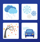
| During quiet autumn weather it is prudent to prepare for possible winter storms and severe weather: “Be Prepared, Stay Safe and know where to find help should you need it”, see Be Winter Ready (www.gov.ie)
|
 |
Met Éireann digital channels analytics during severe weather
Nowadays, there is heightened awareness of weather warnings through social media as well as through traditional Radio and TV. This awareness has been catapulted into the public arena by the colour coding of warnings and this storm naming partnership, fulfilling its main purpose.
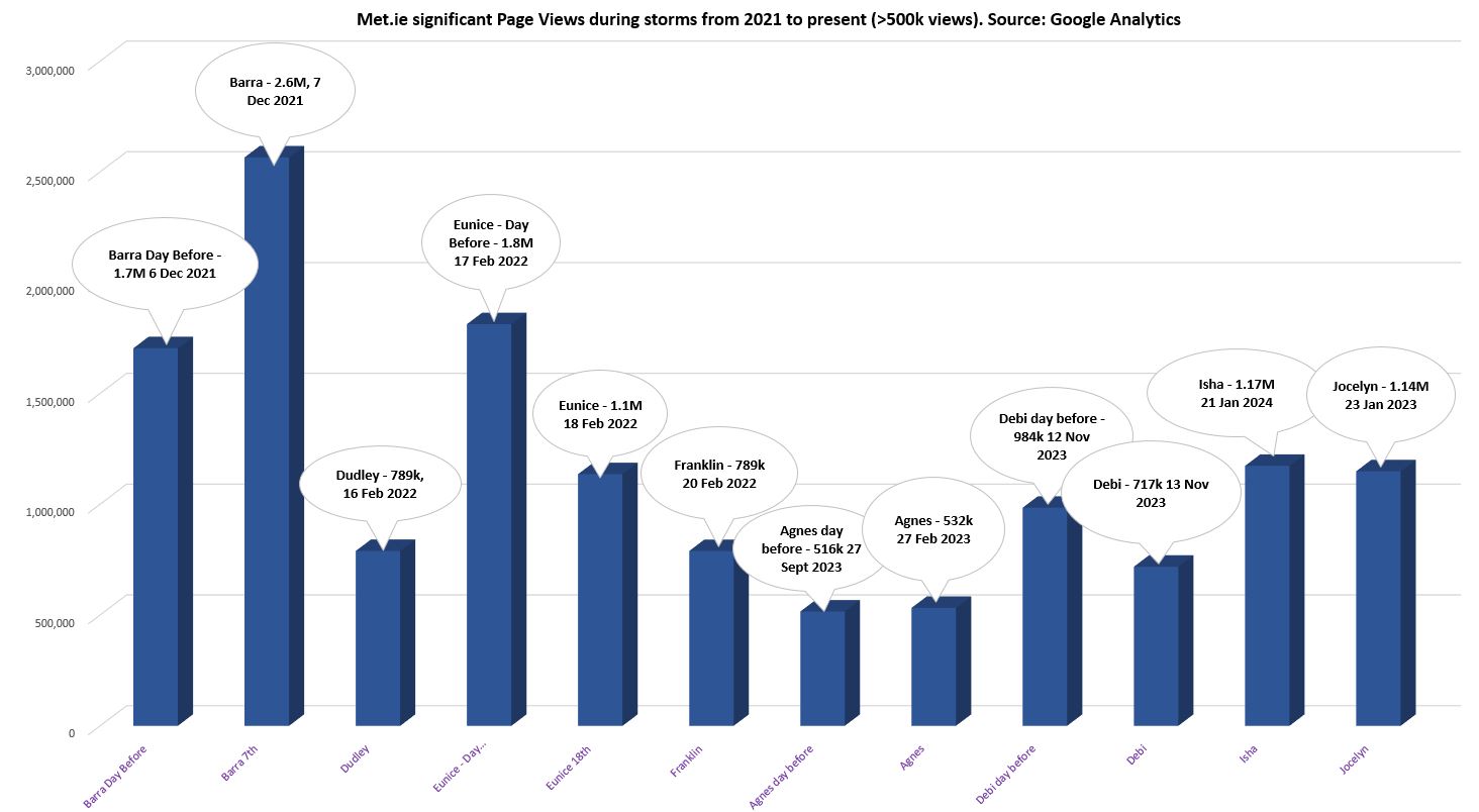
Prior to and during a named storm event there is huge engagement with the Met Éireann website and app. In the last 12 months, there have been 686k users of the Met Éireann app and it was opened over 71 million times. There are approximately 500k hourly forecast searches carried out each day on the Met Éireann app and on our website.
For more information or interview opportunities with Met Éireann spokespersons about Storm Names 2024/25, please contact media@met.ie
