An active jet-stream this weekend has been leading to the development and deepening of low-pressure systems out in the Atlantic steering stormy weather over Ireland.
Two storms have been named by Met Éireann, the 5th and 6th storms of the current storm-naming season, Storm Elin & Storm Fergus. Storm Elin was named overnight and is impacting Ireland today, with orange level wind warnings for Donegal, Dublin & Wicklow for a time. Storm Fergus was named this morning and will impact Ireland later tomorrow and early tomorrow night (Sunday 10th December), with orange level wind warnings for Clare, Galway & Mayo. Yellow level wind warnings have also been issued for both events for many counties along with a status yellow rainfall warning for today for Donegal. For more detail on warnings check met.ie/warnings.
Storm Elin, Saturday 9th December
Taking a look firstly at Storm Elin. On Friday night, Storm Elin developed through the engagement of the left exit of a jet streak with a surface elongated trough out to the west of Ireland. Elin then quickly tracked eastwards over the north of the country this morning, generating strong to gale force west to northwest winds overland. The storm centre will continue to move eastwards over Scotland this afternoon, but with strong to gale force and gusty west to northwest winds in its wake. Those winds will gradually ease early tonight.
Analysis chart showing the development are of Storm Elin below:
Chart showing the jet stream and pressure pattern below: Storm Elin developed in the area highlighted above where elongated trough interacts with the left exit of a jet streak.
Harmonie evolution of Storm Elin is shown below:
Storm Fergus, Sunday 10th December
A rapidly deepening wave depression, currently forming in the mid-Atlantic as it interacts with a left exit region of a jet streak, will continue to develop into Storm Fergus and approach from the southwest through today, tonight and tomorrow. It had an initial pressure of 996hpa and is expected to deepen to around 968hpa out in the Atlantic early tonight, so meeting the criteria for rapid cyclogenesis. It will fill a little then as it tracks towards Ireland and is expected to make landfall tomorrow evening along the west coast with a central pressure of approximately 980hpa. Met Éireann Meteorologist, Michelle Dillon, said: “Strong to gale force southwest winds veering westerly will be developing through Sunday afternoon, evening and early Sunday night as Storm Fergus tracks eastwards across the country, filling a little as it does. Storm surge will lead to high seas and along with the stormy conditions, there’s the possibility of coastal flooding along parts of the west coast, particularly at high tide.”
Analysis chart at 12Z on December 9th, showing the development of Storm Fergus still well out in the Atlantic.
Chart showing the jet stream and pressure pattern below: Storm Fergus is developing from a wave depression where it is interacting with the left exit of a jet streak.
Harmonie evolution of storm Fergus is shown below:
High or very high seas off the west coast tomorrow:
A weekend of stormy weather
By Meteorologist Michelle Dillon
An active jet-stream this weekend has been leading to the development and deepening of low-pressure systems out in the Atlantic steering stormy weather over Ireland.
Two storms have been named by Met Éireann, the 5th and 6th storms of the current storm-naming season, Storm Elin & Storm Fergus. Storm Elin was named overnight and is impacting Ireland today, with orange level wind warnings for Donegal, Dublin & Wicklow for a time. Storm Fergus was named this morning and will impact Ireland later tomorrow and early tomorrow night (Sunday 10th December), with orange level wind warnings for Clare, Galway & Mayo. Yellow level wind warnings have also been issued for both events for many counties along with a status yellow rainfall warning for today for Donegal. For more detail on warnings check met.ie/warnings.
Storm Elin, Saturday 9th December
Taking a look firstly at Storm Elin. On Friday night, Storm Elin developed through the engagement of the left exit of a jet streak with a surface elongated trough out to the west of Ireland. Elin then quickly tracked eastwards over the north of the country this morning, generating strong to gale force west to northwest winds overland. The storm centre will continue to move eastwards over Scotland this afternoon, but with strong to gale force and gusty west to northwest winds in its wake. Those winds will gradually ease early tonight.
Analysis chart showing the development are of Storm Elin below:
Chart showing the jet stream and pressure pattern below: Storm Elin developed in the area highlighted above where elongated trough interacts with the left exit of a jet streak.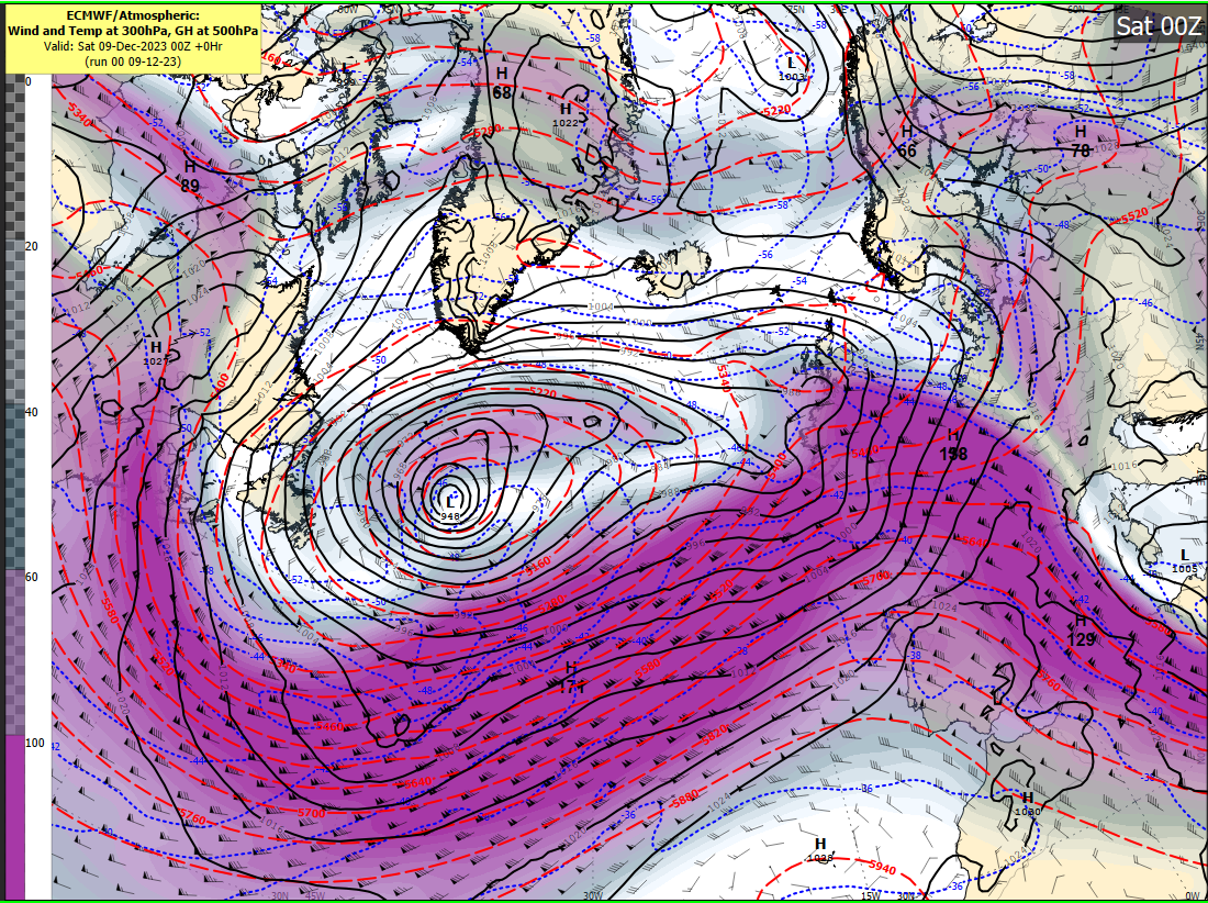
Harmonie evolution of Storm Elin is shown below:
Storm Fergus, Sunday 10th December
A rapidly deepening wave depression, currently forming in the mid-Atlantic as it interacts with a left exit region of a jet streak, will continue to develop into Storm Fergus and approach from the southwest through today, tonight and tomorrow. It had an initial pressure of 996hpa and is expected to deepen to around 968hpa out in the Atlantic early tonight, so meeting the criteria for rapid cyclogenesis. It will fill a little then as it tracks towards Ireland and is expected to make landfall tomorrow evening along the west coast with a central pressure of approximately 980hpa. Met Éireann Meteorologist, Michelle Dillon, said: “Strong to gale force southwest winds veering westerly will be developing through Sunday afternoon, evening and early Sunday night as Storm Fergus tracks eastwards across the country, filling a little as it does. Storm surge will lead to high seas and along with the stormy conditions, there’s the possibility of coastal flooding along parts of the west coast, particularly at high tide.”
Analysis chart at 12Z on December 9th, showing the development of Storm Fergus still well out in the Atlantic.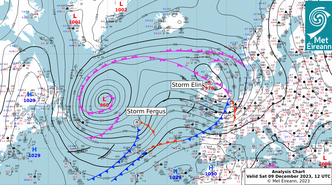
Chart showing the jet stream and pressure pattern below: Storm Fergus is developing from a wave depression where it is interacting with the left exit of a jet streak.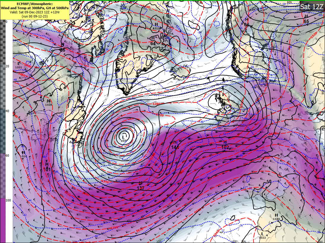
Harmonie evolution of storm Fergus is shown below:
High or very high seas off the west coast tomorrow:
About Us