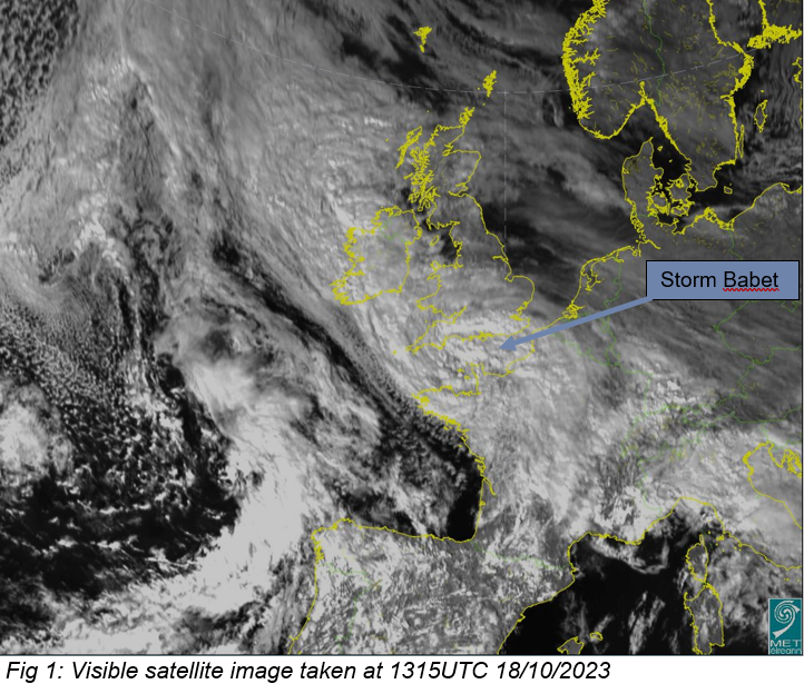
A complex area of low pressure with several embedded fronts, known as Storm Babet, is moving up over the UK today, Wednesday 18th, with its weather fronts bringing bands of heavy rain across Ireland

From the above satellite image we can see large bands of cloud extending from the main low pressure centre just over northern France. These bands of cloud brought significant amounts of rain across southern counties on Tuesday and today (Wednesday).
Met Eireann had orange level rainfall warnings out for Cork, Kerry and Waterford with significant accumulations reported in these counties as of Wednesday morning.
Met Eireann meteorologist Mark Bowe said “coastal parts of Cork got the worst of the rain with reports of flooding and road closures.”
Bowe continued, “the heavy rain is still moving north so we have extended our orange warning in Waterford until later this afternoon and also added Wexford and Wicklow to the orange warnings”
Heavy and persistent rain is due to move over these southern counties today with flooding likely and significant travel disruption.
As the fronts associated with Babet continue to move north over the country we can expect heavy rain at times in all counties and with this Met Eireann also have yellow level rainfall warnings in place across the country.
These warnings will continue right through to later this evening when the last of the heavy rain moves off northern parts of the country tonight
Fig 2 : HARMONIE Rainfall Forecast
Looking ahead to the end of the week Bowe mentioned, “the wet and unsettled weather will stay with us after Babet is gone I’m afraid. Low pressure stays in charge with showers or spells of rain across the country right out to the weekend, with the potential for further yellow rainfall warnings”
Forecasters are monitoring the evolution of Storm Babet and its effects as it passes over the country so be sure to be safe and stay up to date with the latest warnings on www.met.ie/warnings
Fig 3 : ECMWF Mean Sea Level Pressure & Rainfall Forecast
We are monitoring the development of these events closely. Stay safe and keep up to date with the further updates and the latest warnings on https://www.met.ie/warnings.
Heavy rain associated with Storm Babet continues to affect Ireland - updated Wednesday
A complex area of low pressure with several embedded fronts, known as Storm Babet, is moving up over the UK today, Wednesday 18th, with its weather fronts bringing bands of heavy rain across Ireland
From the above satellite image we can see large bands of cloud extending from the main low pressure centre just over northern France. These bands of cloud brought significant amounts of rain across southern counties on Tuesday and today (Wednesday).
Met Eireann had orange level rainfall warnings out for Cork, Kerry and Waterford with significant accumulations reported in these counties as of Wednesday morning.
Met Eireann meteorologist Mark Bowe said “coastal parts of Cork got the worst of the rain with reports of flooding and road closures.”
Bowe continued, “the heavy rain is still moving north so we have extended our orange warning in Waterford until later this afternoon and also added Wexford and Wicklow to the orange warnings”
Heavy and persistent rain is due to move over these southern counties today with flooding likely and significant travel disruption.
As the fronts associated with Babet continue to move north over the country we can expect heavy rain at times in all counties and with this Met Eireann also have yellow level rainfall warnings in place across the country.
These warnings will continue right through to later this evening when the last of the heavy rain moves off northern parts of the country tonight
Fig 2 : HARMONIE Rainfall Forecast
Looking ahead to the end of the week Bowe mentioned, “the wet and unsettled weather will stay with us after Babet is gone I’m afraid. Low pressure stays in charge with showers or spells of rain across the country right out to the weekend, with the potential for further yellow rainfall warnings”
Forecasters are monitoring the evolution of Storm Babet and its effects as it passes over the country so be sure to be safe and stay up to date with the latest warnings on www.met.ie/warnings
Fig 3 : ECMWF Mean Sea Level Pressure & Rainfall Forecast
We are monitoring the development of these events closely. Stay safe and keep up to date with the further updates and the latest warnings on https://www.met.ie/warnings.
About Us