Saturday 19th October 2024 updates:
The meteorological information provided below (see “Overview”) is still valid and Storm Ashley has been confirmed as a rapid deepening or explosive cyclogenesis system. It is worth emphasising the complex scenario Storm Ashley will bring to coastal areas of the country, especially as it coincides with to some of the highest tides of the year.
Storm Ashley will also bring spells of heavy rain on Sunday, which is likely to lead to localised flooding in urban areas and small river catchments, as this rain is falling on already saturated and waterlogged ground.
In view of all this, Met Éireann has updated the weather warnings in place for Sunday and added a new yellow rainfall warning (see latest warnings here). Therefore, it is important to re-emphasize the main impacts expected:
- Coastal flooding: Storm Surges are expected to reach between 0.5m to 1m on Sunday combined with onshore waves and exceptionally high spring tides. Limerick, Clare, Galway, Mayo, Sligo, Leitrim and Donegal coastlines will be particularly at risk for coastal flooding including wave overtopping in low-lying and exposed areas across all day Sunday.
- Large coastal waves: Due to the strong winds, between 1m to 3m waves are forecast in the western bays on Sunday, with offshore waves reaching up to 10 m. This will add to the likelihood of coastal flooding.
- Dangerous conditions at sea
- Localised flooding due to heavy rainfall falling on already saturated and waterlogged ground
- Flying debris, loose objects displaced
- Fallen trees
- Very difficult travelling conditions
- Damage to power lines, power outages
- Damage to already weakened structures
Please remember to “Stay Back, Stay High, Stay Dry” at all times during this event and have a look at the below section “How to Stay Safe in Extreme Weather” for detailed public authorities’ advice.
The following information is valid on Friday 18th October 2024 and until further update
OVERVIEW
Storm Ashley has been named by Met Éireann, becoming the first storm of the 2024/2025 season.
Storm Ashley is a low-pressure system currently developing in the western North Atlantic, on the southern side of the Jet Stream. It is expected to travel quickly eastwards over the Atlantic this weekend, crossing to the northern side of the Jet Stream, becoming positioned in the left exit region (a developmental area of the Jet) which will cause it to undergo rapid deepening later on Saturday.
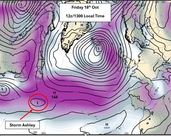
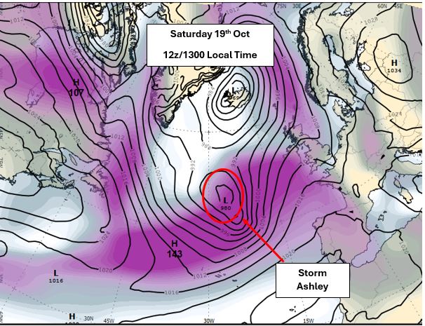
Fig 1- ECMWF 00z Run Friday 18th Oct showing atmospheric pressure (black lines) overlayed with the Jet Stream (purple colour), showing how the jet stream will deepen Ashley over the weekend into a storm depression and steer it to the northwest of Ireland and the UK (see Sunday slide below)
The system will become a storm depression as it swings up to the west and northwest of Ireland on Saturday night and Sunday.
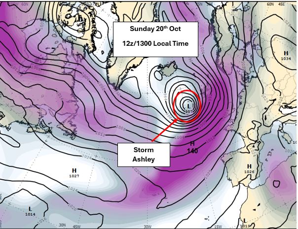
Fig 2 – ECMWF 00z Run Friday 18th Oct showing atmospheric pressure (black lines) overlaid with the Jet Stream (purple colour), showing Storm Ashley in on the northern part of the jet stream, impacting Ireland and the UK on Sunday.
Met Éireann’s meteorologist Liz Walsh, says:
“Storm Ashley will bring strong southerly winds overnight on Saturday night and early Sunday with a second wave of even stronger south-westerly winds, accompanied by damaging gusts across the country, from mid-morning on Sunday, right though the afternoon and into the evening in some parts.”
She continues:
“We are currently in a period of exceptionally high spring tides, and this, tied in with the strong winds and high waves, will substantially increase the risk of coastal flooding, especially along Atlantic coasts”.
At this time, Met Éireann has issued an Orange Wind Warning for some western counties and a Yellow Wind Warning for Ireland, for Sunday, but the warnings are likely to be updated as more information from our high-resolution models comes in and is analysed by our meteorologists (latest warnings here).
KEY INFORMATION – SUMMARY OF IMPACTS
The potential impacts of Storm Ashley are:
- Coastal flooding: Storm Surges are expected to reach between 0.5 metre to 1 metre on Sunday evening combined with onshore waves and high tides Clare, Galway and Mayo Coastlines will be particularly at risk for coastal flooding including wave overtopping in low-lying and exposed areas.
- Large coastal waves: Due to the strong winds between 1m to 3m are forecast in the western bays on Sunday, with offshore waves reach up to 10m. This will add to the like hood of coastal flooding.
- Dangerous conditions at sea
- Flying debris, loose objects displaced
- Fallen trees
- Very difficult travelling conditions
- Damage to power lines, power outages
- Damage to already weakened structures
NOTE THAT:
The warnings are likely to be updated. Please keep in touch with Met Éireann’s social media channels, www.met.ie and the Met Éireann app to stay up to date with the forecast and any warnings’ updates.
The timing and location of extreme weather occurrences can significantly affect their impact. It’s important to note that in any individual weather event, not every location within a warning area may experience the same degree of weather or impacts.
When severe weather is expected, weather and impacts at lower levels are also likely to be experienced. The type and level of impacts can be strongly affected by previous weather conditions. When issuing a warning, Met Éireann takes into consideration the forecasted conditions and thresholds, as well as previous weather conditions that may increase the level of impact expected for particular areas.
HOW TO STAY SAFE IN EXTREME WEATHER
- Stay up-to date with the forecast and the warnings for your county on met.ie, the Met Éireann app or Met Éireann socials (@meteireann).
- Check in with your local authority and emergency management stakeholders (Irish Coast Guards, Gardaí, etc) via their websites and social channels to see how your area will be/is affected.
- Ensure your mobile is phone is fully charged to enable communication in advance of the event and keep local emergency numbers in your phone.
- Keep a small amount of food, medical and water supplies in case it’s dangerous to step out of the home.
- Advance planning for flooding: You can consult the OPW flood maps, which show areas that may be at risk of flooding based on historical data (see www.floodinfo.ie).
- Stay away from coastal areas during the period. Remember the advice from the Irish Coast Guard: “Stay Back, Stay High, Stay Dry”.
- Don’t try to walk, cycle or drive through flooded areas, the depth of the water can be deceiving.
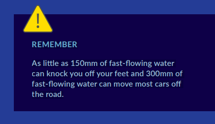
- Remember: As little as 150mm of fast-flowing water can knock you off your feet and 300mm of fast-flowing water can move most cars off the road.
- While on the road in strong winds, beware of fallen trees or other debris and high sided vehicles, particularly when overtaking. If you are driving a high sided vehicle, try to anticipate exposed sections of roadway where winds will be stronger.
- ESB Networks is highlighting the dangers posed by fallen live wires and advises the public and the emergency services to stay away from fallen cables and to report such cases immediately. ESB Emergency Services can be contacted at 1800 372 999.
- You can monitor www.powercheck.ie in regards to power restoration times
- “Be Winter Ready”: Follow recommendations before, during and after the event on gov.ie – Be Winter Ready (www.gov.ie)
WHY AND HOW ARE STORMS NAMED?
Storms are named when they could cause ‘medium’ or ‘high’ impacts in one of the three partner countries. This enables consistent, authoritative messaging to the public and other stakeholders to help them to prepare for and stay safe during potentially severe weather events.
Since 2015, Met Éireann and the UK Met Office have been working together on the naming programme and were joined by the Netherlands’ KNMI in 2019, to form the ‘western group’ of European weather services.
When a storm is forecast, the national weather service that expects the biggest impact from the severe weather to hit its region, or is likely to be first affected by it, names the storm. Storm naming happens in conjunction with orange/red weather warnings, which could be for wind, rain or snow, or a combination of these conditions. Those warnings are, in turn, issued based on a combination of numerical thresholds and the potential impacts foreseen.
HOW ARE STORM NAMES CHOSEN?
Met Éireann, the UK Met Office and KNMI publish a new list of storm names for each Storm Season, which commences on 1st September.
This 2024/25 season, each of the three meteorological services contributed seven names to the season’s list. Met Éireann’s contributions to this year’s list were taken from more than 500 suggestions by primary school children participating in ESB Science Blast last February.
The full 2024/25 list is Ashley, Bert, Conall, Darragh, Éowyn, Floris, Gerben, Hugo, Izzy, James, Kayleigh, Lewis, Mavis, Naoise, Otje, Poppy, Rafi, Sayuri, Tilly, Vivienne, Wren, with Met Éireann contributing the names for C, D, H, I, N, P and V (names chosen by Met Éireann in bold).
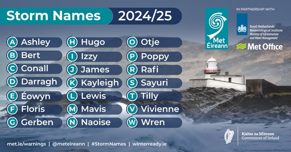
(Note – letters Q, U, X, Y, Z are not included, in line with the US National Hurricane Centre naming convention.)
PAST STORM SEASONS OVERVIEW
- Last season (2023/24) there were fourteen (14) named storms affecting the area, twelve (12) of which were named by the Western Europe Group, formed by UK Met Office, KNMI and Met Éireann, and the other two (2) storms (Elisa and Geraldine) by the Southwestern Europe Group, made up of France, Portugal and Spain.
- 2023/24 was the season with the highest number of storms named in a season by the Western Europe Group list (12 storms)
- 2023/24 is the first season since the initiative began in 2015 in which an ‘L’ storm was named from the list of the Western Europe Group – Storm Lilian in August 2024.
- The lowest number of named storms since the initiative began was the four (4) named in 2022/23.
- Prior to the 2023/24 season, the highest number of named storms occurred in the 2015/16 and 2017/18 seasons, with eleven (11) named storms in each.
- Since 2015/16, there has been an average of eight (8) named storms in each season
- Season 2015/2016 remains the season with the greatest number of storms reaching Storm Force 10, as nine (9) of the eleven (11) named storms observed Storm Force 10 sustained wind speeds at Atlantic coastal stations.
- During the past season 2023/24, there were three (3) named storms with Storm Force 10 sustained wind speeds or higher:
- Storm Force 10 sustained (10-minute mean) wind speeds were observed during named Storm Fergus (91 km/h) and Storm Jocelyn (96 km/h), at Mace Head (coastal), Co Galway on Sunday 10th December 2023 and Tuesday 23rd January 2024 respectively.
- Violent Storm Force 11 sustained wind speeds were observed at Mace Head (coastal), Co Galway during Storm Isha on Sunday 21st January 2024. Before that, Violent Storm Force winds had been last observed during Storm Eunice on Friday 18th February 2022.
- No Hurricane strength sustained/mean winds at any Met Éireann wind station have been observed since the Storm Naming initiative began. Storm Ellen in August 2020 came very close to observing winds of this strength, with 111 km/h at Roches Point, Co Cork. The last hurricane force winds affecting Ireland were observed during Storm Darwin on Wednesday 12th February 2014. Hurricane force winds have been observed at coastal western stations, mainly in January (half the time), twice in December and once in February, March and September.
- It is not uncommon to have storms named in the month of October. Since the naming initiative started, 5 out of 9 seasons have had October storms, including Ophelia on 16th October 2017 and Babet last year. Prior to storm Ashley, a total of 7 storms have impacted Ireland in October, since 2015.
For more information on storm names and past storms, see Storm Centre and Major Weather Events