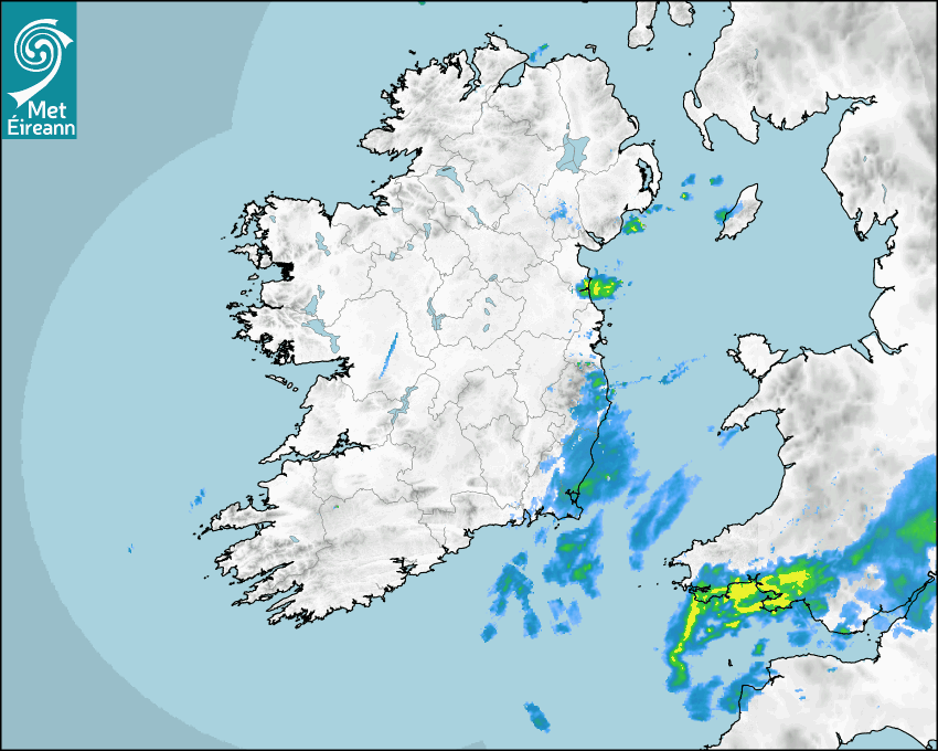

Latest Rainfall Radar showing live precipitation and the last 90 minutes precipitation over Ireland, updated every 5 minutes. Precipitation can be rain, hail or snow. Accumulations can refer to rainfall only.
Lightning strikes, when they occur, are displayed as a cross. Initially, they are red but change to orange and then yellow after a period, then disappear © Met Office ATDNet.
Ground Clutter may appear (South Co. Dublin), bright bands and spokes may also be present in images. They are artefacts (false echoes) of rainfall radar systems and should be ignored. Further information on Radar here
Met Éireann forecasters manually produce the weather icons for midday and midnight to reflect the predicted major weather type for these times.
The rainfall forecast is direct model output from Numerical Weather Prediction models but is a guideline only. Rain refers to precipitation, which can be rain, sleet or snow. It forecasts how much rain will fall (in mm) hourly during the previous hour (accumulations), then in 3 hourly and finally 6 hourly accumulations up to 7 days. This service is based on data and products of the European Centre for Medium-range Weather Forecasts (ECMWF)
The wind is direct model output from Numerical Weather Prediction models but is a guideline only. It forecasts the strength of the wind (in knots and km/h) at 10m for the top of each hour, in hourly, then 3 hourly and finally 6 hourly intervals up to 7 days. The wind arrow tip points in the direction the wind is blowing and the tail length indicates wind strength. However, in the text forecast below, it is described as where it is blowing from. This service is based on data and products of the European Centre for Medium-range Weather Forecasts (ECMWF).
The temperature is direct model output from Numerical Weather Prediction models but is a guideline only. It forecasts air temperature on land and over sea in °C for the top of each hour, 3 hourly and finally 6 hourly intervals up to 7 days. Minus zero (-0) indicates values between 0 to -0.5°C. This service is based on data and products of the European Centre for Medium-range Weather Forecasts (ECMWF).
The Mean Sea Level Pressure (MSLP) is direct model output from Numerical Weather Prediction models but is a guideline only. It forecasts the MSLP in hecto Pascals (hPa) for the top of that hour initially in 3 hourly intervals, then 6 hourly. This service is based on data and products of the European Centre for Medium-range Weather Forecasts (ECMWF).
National Forecast
27 April 2024 06:30
Today
A cold start this morning with any frost and mist patches clearing quickly to leave a generally bright day with a mix of sunny spells and scattered showers. However, more persistent rain will affect the southeast for a short time this morning. The odd heavy downpour is possible this afternoon across the west and north with a small chance of hail. Maximum temperatures of 9 to 12 degrees in a generally moderate northeasterly breeze.
Tonight
Any showers will die out early on Saturday night to leave it dry and mostly clear. A cold night for late April with a touch of frost likely along with some mist or fog patches. Lowest temperatures of -2 to +3 degrees in light northerly or variable breezes.
Tomorrow
Another cold start on Sunday but with plenty of morning sunshine. Showers will develop during the day, some turning heavy and prolonged in the west and southwest. Highest temperatures ranging from 10 to 13 degrees with a moderate southwest to west breeze developing.
Met News

19th April 2024
European State of the Climate 2023 & Climate of Ireland 2023
Issued Monday 22nd April 2024 Europe (From Coperni... more

19th April 2024
Daily UV Forecasts now available on Met.ie
The daily Solar UV Index level is now available wi... more

10th April 2024
We're Hiring Two Postdoctoral Researchers
Met Éireann, a line division of the Department of... more

08th April 2024
2024 Nematodirus Forecast
Taken from the Department of Agriculture, Food and... more