Réamhaisnéis limistear na farraige
Forecast valid from: 06:00, Monday 29 April 2024 until 06:00, Tuesday 30 April 2024
Small Craft Warning
(1) Southerly winds will reach force 6 or higher at times today on Irish coasts from Bloody Foreland to Carnsore Point to Erris Head, becoming confined to eastern and northeastern coasts for the afternoon and evening. (2) Southwest or west winds, veering northwest to north north of Loop Head, will increase to force 6 and gusty on Irish coasts from Roches Point to Valentia to Erris Head, for a time this morning. (3) Southeasterly winds, veering southerly, will increase to force 6 or higher at times on Irish coasts from Carlingford Lough to Dungarvan on Monday night
Gale Warning
Southerly winds will occasionally reach gale force 8 and gusty on Monday morning and afternoon on Irish Coastal Waters from Carlingford Lough to Wicklow Head to Hook Head and on the Irish Sea.
Meteorological Situation at 03:00 UTC
Ireland lies in a strengthening mostly southerly or cyclonic variable airflow, with an area of low pressure of 997 hPa centered 70 nautical miles to the west of Slyne Head and moving in over Ireland today. Its associated frontal troughs will continue to track eastwards across the area this morning, with showers following.
Gale Warning: In effect
Small Craft Warning: In effect
Heavy Swell (>4m) : Nil
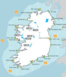
Forecast for Irish coastal waters from Roches Point to Mizen Head to Loop Head
Wind: Southwest to west force 5 to 7 and gusty. Veering westerly imminent and decreasing mostly force 4 or 5. Soon backing southwesterly and decreasing force 3 to 5. Later decreasing variable force 2 to 4.
Weather: Rain clearing to occasional showers imminent. Rain spreading northwards on Monday night, heavy at times.
Visibility: Decreasing moderate to poor in precipitation, otherwise good.
Forecast for Irish coastal waters from Loop Head to Slyne Head to Erris Head
Wind: Becoming westerly to northerly and increasing force 5 or 6 and gusty imminent, decreasing northwest force 4 or 5 later this morning. Soon decreasing westerly force 3 or 4 and further decreasing variable force 2 or 3 this evening. Later increasing easterly force 4 or 5.
Weather: Rain clearing to occasional showers imminent. Rain spreading northwards on Monday night, heavy at times.
Visibility: Decreasing moderate to poor in precipitation, otherwise good.
Forecast for Irish coastal waters from Erris Head to Malin Head to Fair Head
Wind: Cyclonic variable force 3 or 4 imminent. Soon westerly force 4 or 5. Decreasing southwest or variable force 2 to 4 early Monday night. Later becoming easterly force 4 or 5.
Weather: Rain soon clearing to occasional showers.
Visibility: Decreasing moderate to poor in precipitation, otherwise good.
Forecast for Irish coastal waters from Fair Head to Howth Head to Roches Point and the Irish Sea.
Wind: South or southwest mostly force 6 to gale force 8 and gusty imminent. Soon decreasing south or southwest force 5 to 7. Decreasing southerly force 4 or 5 for a time tonight. Later increasing south or southeast force 5 to 7 and occasionally gusty. Decreasing southwest force 4 to 6 in southern areas by the end of the period.
Weather: Rain clearing eastwards this morning and early afternoon, then cloudy to fair with scattered showers. Later cloudy with rain spreading northwards, becoming heavy at times.
Visibility: Decreasing moderate to poor in precipitation, otherwise good.
Outlook for a further 24 hours until 06:00, Wednesday 01 May 2024
Cyclonic variable winds will increase fresh to strong at times on Tuesday in most sea areas, increasing to near gale force in the east and north, decreasing moderate to fresh on Tuesday night. Cyclonic variable winds will be light to moderate in the west and southwest and later in the south. Weather: Rain clearing northwards on Tuesday morning, with showers following, some heavy and with a chance of thunderstorms.
Forecast issued at: 06:00, Monday 29 April 2024
All times are local unless specified