Sea Area Forecast
Forecast valid from: 11:00, Monday 03 August 2026 until 12:00, Tuesday 04 August 2026
Small Craft Warning
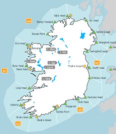
1. Southeast to east winds will reach force 6 or higher on Irish coasts from Roches Point to Valentia to Slyne Head this morning (Monday).
2.Northeasterly winds will reach force 6 or higher at times this afternoon, on Irish coasts from Slyne Head to Rossan Point to Malin Head.
3. Southeast to east winds will force 6 at times early on Tuesday on Irish coasts from Malin Head to Howth Head to Carnsore Point, and on the Irish sea.
Gale Warning
Nil
Meteorological Situation at 09:00 UTC
A complex and slow moving depression of 1003hPa centred approximately 200 nautical miles southwest of Valentia generates a moderate to strong easterly airflow over Ireland. Associated fronts embedded within the flow will track over Ireland today bringing heavy and persistent rain at times.
Small Craft Warning: In effect
Heavy Swell (>4m) : No
Forecast for Slyne Head to Rossan Point to Belfast Lough
Wind: East to northeast force 5 or 6. Soon easing east force 3 to 5. Later becoming southerly or cyclonic variable force 2 to 4. Increasing southeast force 5 or 6 from Malin Head to Belfast Lough. Becoming cyclonic variable force 2 to 4 by the end of the period.
Weather: Cloudy with showers or longer spells of rain, heavy at times. Chance of isolated thunderstorms.
Visibility: Good reducing moderate or poor in precipitation and mist. Mist patches also.
Forecast for Belfast Lough to Wicklow Head to Hook Head and for the Irish Sea
Wind: East to southeast force 3 or 4, and occasionally force 5. Easing southeast force 2 to 4 imminent. Soon increasing southeast force 4 or 5. Remaining variable force 3 or less on the Irish Sea. Later increasing southerly force 3 to 5 and occasionally force 6.
Weather: Fair to cloudy with showers or longer spells of rain, heavy at times. Showers developing later, heavy at times. Chance of isolated thunderstorms. Mist patches also.
Visibility: Good reducing moderate or poor in precipitation and mist.
Forecast for Hook Head to Roches Point to Valentia
Wind: Southeast force 3 to 5, and occasionally force 6. Soon veering west to southwest force 3 or 4. Later becoming southwest force 4 and occasionally force 5.
Weather: Cloudy with showers or longer spells of rain, heavy at times. Chance of isolated thunderstorms. Mist patches also.
Visibility: Good reducing moderate or poor in precipitation and mist.
Forecast for Valentia to Loop Head to Slyne Head
Wind: Southeast force 4 to 6, easing southwest or variable force 3 or less imminent. Soon increasing southwest force 3 or 4. Later becoming westerly or cyclonic variable force 3 or 4. Veering northwest force 4 or 5 by the end of the period.
Weather: Cloudy to fair with showers or longer spells of rain, heavy at times. Chance of isolated thunderstorms. Mist patches also.
Visibility: Good reducing moderate or poor in precipitation and mist.
Outlook for a further 24 hours until 12:00, Wednesday 05 August 2026
Moderate to strong northwest winds will increase to near gale on western coasts Tuesday night. On the east coast, moderate southerly winds will increase fresh to strong and veer westerly on Tuesday night and Wednesday morning, occasionally reaching near gale force on the Irish Sea. \n\nWeather: Scattered showers or spells of rain, occasionally heavy with the chance of thunderstorms. Becoming mainly dry in the east on Wednesday with rain persisting in the north and northwest, heavy at times.
Forecast issued at: 11:00, Monday 03 August 2026
All times are local unless specified