Sea Area Forecast
Forecast valid from: 12:00, Sunday 23 February 2025 until 12:00, Monday 24 February 2025
Small Craft Warning
South to southwest winds will reach force 6 or higher today on all Irish coasts, becoming confined tomorrow morning to Irish coasts from Mizen Head to Rossan Point to Carlingford Lough.
Gale Warning
Southerly winds will reach gale force 8 or strong gale force 9 at times today on all Irish coastal waters and on the Irish Sea, becoming confined this evening and overnight to Irish coastal waters from Slyne Head to Rossan Point to Malin Head.
Atlantic Swell
Developing on southwest and west coasts this afternoon.
Meteorological Situation at 09:00 UTC
Ireland lies in a near gale to gale force southerly airflow generated by a depression of 949hPa centred approximately 650 nautical miles northwest of Erris Head, which will track to the south coast of Iceland today.
Gale Warning: In effect
Small Craft Warning: In effect
Heavy Swell (>4m) : yes
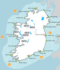
Forecast for Irish coastal waters from Slyne Head to Rossan Point to Malin Head
Wind: Southwest force 7 to gale force 8. Soon decreasing force 6 or 7.
Weather: Fair to cloudy with showers, with the chance of hail and isolated thunderstorms.
Visibility: Decreasing moderate or poor in precipitation.
Forecast for Irish coastal waters from Malin Head to Carnsore Point to Slyne Head and for the Irish Sea
Wind: Southwest force 7 to gale force 8, touching strong gale force 9 in the Irish Sea. Decreasing force 6 or 7 imminent. Later decreasing force 5 or 6.
Weather: Rain, heavy at times. Fair with showers imminent, with a chance of hail and isolated thunderstorms.
Visibility: Decreasing moderate or poor in precipitation.
Outlook for a further 24 hours until 12:00, Tuesday 25 February 2025
Fresh to near gale force southwesterly winds veering westerly and decreasing fresh to strong and gusty Monday night. Further decreasing moderate to fresh in eastern sea areas later. Weather: Fair with showers, some heavy with the chance of hail and isolated thunderstorms.
Forecast issued at: 12:00, Sunday 23 February 2025
All times are local unless specified