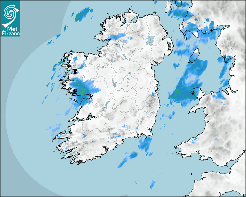

Latest Rainfall Radar showing live precipitation and the last 90 minutes precipitation over Ireland, updated every 5 minutes. Precipitation can be rain, hail or snow. Accumulations can refer to rainfall only.
Lightning strikes, when they occur, are displayed as a cross. Initially, they are red but change to orange and then yellow after a period, then disappear © Met Office ATDNet.
Ground Clutter may appear (South Co. Dublin), bright bands and spokes may also be present in images. They are artefacts (false echoes) of rainfall radar systems and should be ignored. Further information on Radar here
Met Éireann forecasters manually produce the weather icons for midday and midnight to reflect the predicted major weather type for these times.
The rainfall forecast is direct model output from Numerical Weather Prediction models but is a guideline only. Rain refers to precipitation, which can be rain, sleet or snow. It forecasts how much rain will fall (in mm) hourly during the previous hour (accumulations), then in 3 hourly and finally 6 hourly accumulations up to 7 days. This service is based on data and products of the HARMONIE-AROME and the European Centre for Medium-range Weather Forecasts (ECMWF) models.
The wind is direct model output from Numerical Weather Prediction models but is a guideline only. It forecasts the strength of the wind (in knots and km/h) at 10m for the top of each hour, in hourly, then 3 hourly and finally 6 hourly intervals up to 7 days. The wind arrow tip points in the direction the wind is blowing and the tail length indicates wind strength. However, in the text forecast below, it is described as where it is blowing from. This service is based on data and products of the HARMONIE-AROME and the European Centre for Medium-range Weather Forecasts (ECMWF) models.
The temperature is direct model output from Numerical Weather Prediction models but is a guideline only. It forecasts air temperature on land and over sea in °C for the top of each hour, 3 hourly and finally 6 hourly intervals up to 7 days. Minus zero (-0) indicates values between 0 to -0.5°C. This service is based on data and products of the HARMONIE-AROME and the European Centre for Medium-range Weather Forecasts (ECMWF) models.
The Mean Sea Level Pressure (MSLP) is direct model output from Numerical Weather Prediction models but is a guideline only. It forecasts the MSLP in hecto Pascals (hPa) for the top of that hour initially in 3 hourly intervals, then 6 hourly. This service is based on data and products of the HARMONIE-AROME and the European Centre for Medium-range Weather Forecasts (ECMWF) models.
Réamhaisnéis Náisiúnta
13 December 2025 16:49
Inniu
Mostly cloudy this evening with outbreaks of rain and drizzle, turning heavier in the west and southwest later. Windy in the west and northwest, with strong and gusty southerly winds and gales near the coast, and breezy elsewhere, with moderate to fresh southwesterly winds.
Anocht
Wet and blustery tonight with widespread outbreaks of rain and drizzle. The rain will be heavy at times, particularly towards the morning in the southwest, west and northwest. Mild with lowest temperatures of 10 to 12 degrees and fresh to strong and gusty southwesterly winds.
Amárach
Continuing wet and blustery across the country on Sunday morning, with outbreaks of rain, turning heavy at times, especially in the south and west. With high river levels and saturated soils, river and surface water flooding are likely, particularly in the south and west. Winds will ease in the west and northwest in the afternoon but it will remain blustery across southern and southeastern counties, especially near the coast. Highest temperatures of 11 to 13 degrees with fresh to strong and gusty southwesterly winds, easing light to moderate in the west and northwest in the afternoon.
Met News

10ú Nollaig 2025
New study links climate change to increased rainfall and flood risk
A new rapid attribution study from Maynooth Univer... léigh níos mó

03ú Nollaig 2025
Climate Statement for Autumn 2025
Mild and very wet Meteorological Autumn 2025 was t... léigh níos mó

02a Nollaig 2025
Climate Statement for November 2025
Wet overall. Very mild first half, cooler second h... léigh níos mó