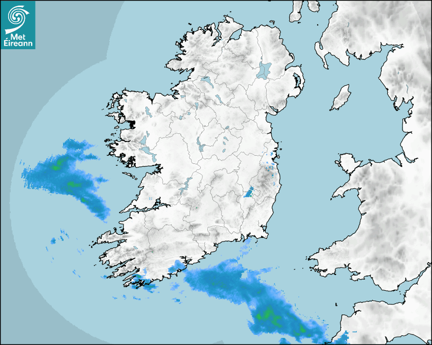

Latest Rainfall Radar showing live precipitation and the last 90 minutes precipitation over Ireland, updated every 5 minutes. Precipitation can be rain, hail or snow. Accumulations can refer to rainfall only.
Lightning strikes, when they occur, are displayed as a cross. Initially, they are red but change to orange and then yellow after a period, then disappear © Met Office ATDNet.
Ground Clutter may appear (South Co. Dublin), bright bands and spokes may also be present in images. They are artefacts (false echoes) of rainfall radar systems and should be ignored. Further information on Radar here
Met Éireann forecasters manually produce the weather icons for midday and midnight to reflect the predicted major weather type for these times.
The rainfall forecast is direct model output from Numerical Weather Prediction models but is a guideline only. Rain refers to precipitation, which can be rain, sleet or snow. It forecasts how much rain will fall (in mm) hourly during the previous hour (accumulations), then in 3 hourly and finally 6 hourly accumulations up to 7 days. This service is based on data and products of the HARMONIE-AROME and the European Centre for Medium-range Weather Forecasts (ECMWF) models.
The wind is direct model output from Numerical Weather Prediction models but is a guideline only. It forecasts the strength of the wind (in knots and km/h) at 10m for the top of each hour, in hourly, then 3 hourly and finally 6 hourly intervals up to 7 days. The wind arrow tip points in the direction the wind is blowing and the tail length indicates wind strength. However, in the text forecast below, it is described as where it is blowing from. This service is based on data and products of the HARMONIE-AROME and the European Centre for Medium-range Weather Forecasts (ECMWF) models.
The temperature is direct model output from Numerical Weather Prediction models but is a guideline only. It forecasts air temperature on land and over sea in °C for the top of each hour, 3 hourly and finally 6 hourly intervals up to 7 days. Minus zero (-0) indicates values between 0 to -0.5°C. This service is based on data and products of the HARMONIE-AROME and the European Centre for Medium-range Weather Forecasts (ECMWF) models.
The Mean Sea Level Pressure (MSLP) is direct model output from Numerical Weather Prediction models but is a guideline only. It forecasts the MSLP in hecto Pascals (hPa) for the top of that hour initially in 3 hourly intervals, then 6 hourly. This service is based on data and products of the HARMONIE-AROME and the European Centre for Medium-range Weather Forecasts (ECMWF) models.
Réamhaisnéis Náisiúnta
22 April 2026 13:30
Inniu
Mostly dry and breezy with sunny spells, some of which will be hazy, but with cloud spreading from the southwest through the afternoon and evening. Some patchy light rain or drizzle will clip southwestern coastal areas. Highest temperatures today of 11 to 15 degrees, with moderate to fresh easterly winds, stronger at times near eastern, southern, and southwestern coasts.
Anocht
Dry tonight with variable cloud amounts. Lowest temperatures of 3 to 10 degrees, coolest in Ulster and mildest in the southwest, with a moderate easterly breeze.
Amárach
A dry day with sunny spells. Feeling warmer than of late with highest temperatures of 14 to 18 degrees, warmest in the west. Breezy though, with moderate to fresh southeasterly winds.
Met News

09ú Aibreán 2026
2026 Nematodirus Forecast
From Department of Agriculture, Food and the Marin... léigh níos mó

02a Aibreán 2026
Climate Statement for March 2026
Mild and sunny. Wet for most, drier in the South M... léigh níos mó

23ú Márta 2026
World Meteorological Day, 2026 - Observing Today, Protecting Tomorrow
State of the Global Climate report issued today as... léigh níos mó