Sea Area Forecast
Forecast valid from: 12:00, Thursday 30 July 2026 until 12:00, Friday 31 July 2026
Small Craft Warning
Nil
Gale Warning
Nil
Meteorological Situation at 09:00 UTC
A complex depression of 997hPa centred in the Norwegian Sea generates an unstable moderate to fresh west to northwest airflow over Ireland.
Heavy Swell (>4m) : No
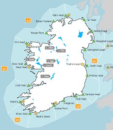
Forecast for Mizen Head to Erris Head to Fair Head
Wind: Mainly west to northwest force 4 or 5, imminent becoming westerly. Soon decreasing force 3 or 4. Later increasing force 4 or 5.
Weather: Fair to cloudy with scattered showers, some possibly heavy in the northwest. Isolated mist patches also.
Visibility: Reducing moderate or poor in precipitation and mist, otherwise good.
Forecast for Fair Head to Carlingford Lough to Wicklow Head and for the Irish Sea
Wind: Northwest force 3 or 4, occasionally force 5 near the North Channel at first. Imminent decreasing westerly or variable force 2 to 4. Occasionally touching force 5 soon. Later becoming mainly westerly force 3 or 4.
Weather: Fair to cloudy with isolated showers. Isolated mist patches also.
Visibility: Mostly good, but reducing moderate or poor in precipitation and mist.
Forecast for Wicklow Head to Hook Head to Mizen Head
Wind: West to northwest or variable force 2 to 4. Imminent increasing westerly force 4 or 5. Soon veering northwest. Decreasing force 3 or 4 later and gradually backing west to southwest by the end of the period.
Weather: Fair to cloudy with isolated showers. Isolated mist patches also.
Visibility: Mostly good, but reducing moderate or poor in precipitation and mist.
Outlook for a further 24 hours until 12:00, Saturday 01 August 2026
Moderate to fresh westerly winds, occasionally strong along the south coast Friday afternoon and evening. Becoming mainly northwest Friday night and decreasing light in the southwest on Saturday morning. Weather; Fair to cloudy. Showers, some possibly heavy in the north and west during Friday. Showers becoming isolated later.
Forecast issued at: 12:00, Thursday 30 July 2026
All times are local unless specified