Sea Area Forecast
Forecast valid from: 06:00, Saturday 20 December 2025 until 06:00, Sunday 21 December 2025
Small Craft Warning
South to southwest winds will reach force 6 or higher on all Irish coasts throughout the period.
Gale Warning
Southeast to south winds will reach gale force tonight (Friday night) on Irish coastal waters from Roches Point to Loop Head to Erris Head, extending to Irish coastal waters from Howth Head to Mizen Head to Rossan Point through tomorrow.
Atlantic Swell
Yes
Meteorological Situation at 03:00 UTC
A depression of 969hPa centered to the southwest of Iceland generates a strong to gale force south to southeast airflow over Ireland. There are embedded troughs within the flow, with associated weather fronts passing over Ireland today.
Gale Warning: In effect
Small Craft Warning: In effect
Heavy Swell (>4m) : yes
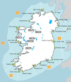
Forecast for Irish coastal waters from Bloody Foreland to Howth Head to Roche's Point and for the Irish Sea
Wind: Southerly force 5 to 7, occasionally gale force 8. Soon decreasing westerly force 3 or 4 or variable between Hook Head and Roches Point. Later decreasing force 5 to 7 between Bloody Foreland and Carnsore Point and on the Irish sea.
Weather: Mostly cloudy with scattered showers, merging into longer spells of rain.
Visibility: Good reducing moderate or poor in precipitation.
Forecast for Irish coastal waters from Roche's Point to Loop Head to Bloody Foreland
Wind: Southeast force 7 or gale force 8, veering westerly force 5 to 7 and occasionally gale force 8 imminent. Soon decreasing westerly or variable force 3 or 4. Later becoming cyclonic variable force 2 to 4, and occasionally force 5 between Mizen Head and Valentia.
Weather: Cloudy with spells of rain. Scattered showers developing later.
Visibility: Good reducing moderate or poor in precipitation.
Outlook for a further 24 hours until 06:00, Monday 22 December 2025
Mostly light to moderate or variable southerly winds. Fresh to strong and gusty southeast winds in the north and east, and on the Irish seas, will back easterly and ease moderate to fresh on Sunday evening. Light to moderate or variable easterly winds will extend to all coasts on Monday. Fair to cloudy with scattered showers, or longer spells of rain.
Forecast issued at: 06:00, Saturday 20 December 2025
All times are local unless specified